
Fitxer:2016-Brussels-Bombings-OpenStreetMap.png

Mida d'aquesta previsualització: 800 × 521 píxels. Altres resolucions: 320 × 208 píxels | 640 × 417 píxels | 1.024 × 667 píxels | 1.280 × 834 píxels | 2.560 × 1.668 píxels | 4.924 × 3.208 píxels.
Fitxer original (4.924 × 3.208 píxels, mida del fitxer: 19,66 Mo, tipus MIME: image/png)
| Aquest fitxer i la informació mostrada a continuació provenen del dipòsit multimèdia lliure Wikimedia Commons. |
| Descripció |
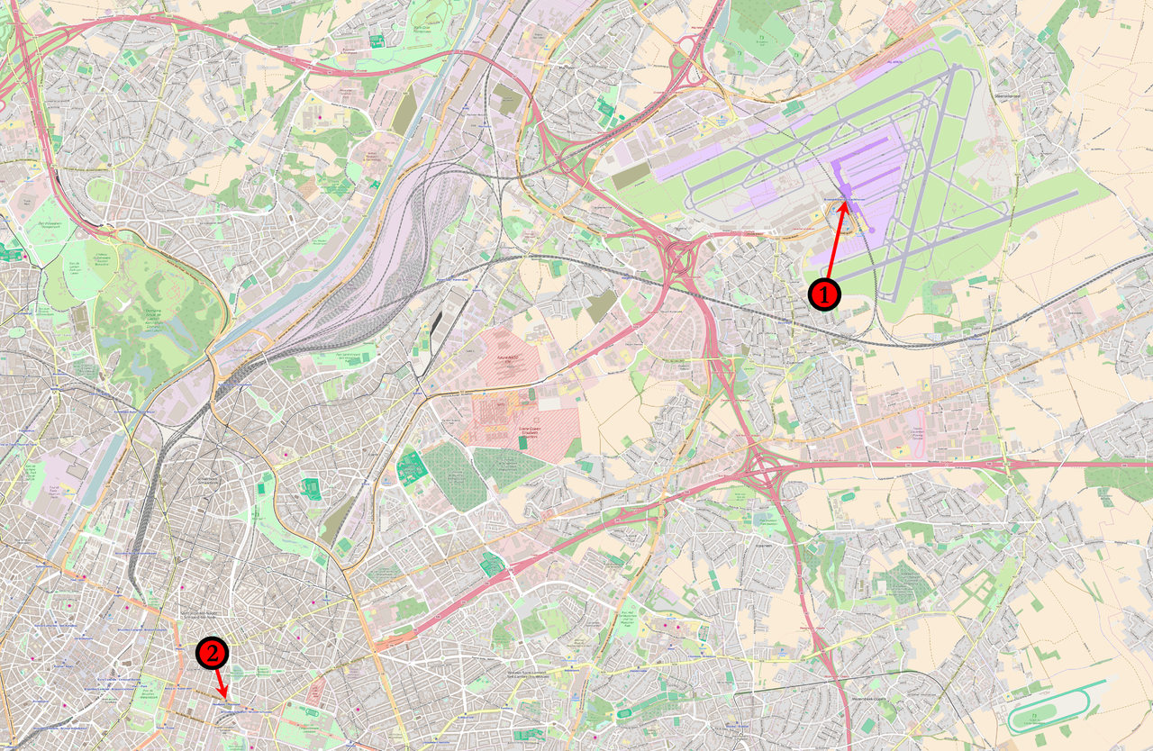
English: Map of the March 2016 Brussels bombings in relation to each other. (1) 08:00 : Concourse B of Brussels Airport. (2) 09:15 : Brussels Maelbeek metro station |
|||
| Data | ||||
| Font | Base map from OpenStreetMap | |||
| Autor | Veggies | |||
| Permís (Com reutilitzar aquest fitxer) |
Aquest fitxer està publicat sota la llicència de Creative Commons Reconeixement i Compartir Igual 2.0 Genèrica.
|
Historial del fitxer
Cliqueu una data/hora per veure el fitxer tal com era aleshores.
| Data/hora | Miniatura | Dimensions | Usuari/a | Comentari | |
|---|---|---|---|---|---|
| actual | 01:05, 23 març 2016 | | 4.924 × 3.208 (19,66 Mo) | Veggies | {{Information |Description ={{en|1=Map of the March 2016 Brussels bombings in relation to each other.<br /> '''(1)''' 08:00 : Concourse B of Brussels Airport.<br />'''(2)''' 09:15 : ''Brussels Maelbeek metro station''}} |Source =Base map fro... |
Ús del fitxer
La pàgina següent utilitza aquest fitxer:
Ús global del fitxer
Utilització d'aquest fitxer en altres wikis:
- Utilització a ar.wikipedia.org
- Utilització a az.wikipedia.org
- Utilització a da.wikipedia.org
- Utilització a en.wikipedia.org
- Utilització a et.wikipedia.org
- Utilització a fo.wikipedia.org
- Utilització a ga.wikipedia.org
- Utilització a hi.wikipedia.org
- Utilització a hu.wikipedia.org
- Utilització a lt.wikipedia.org
- Utilització a lv.wikipedia.org
- Utilització a no.wikipedia.org
- Utilització a pl.wikipedia.org
- Utilització a pt.wikipedia.org
- Utilització a sco.wikipedia.org
- Utilització a simple.wikipedia.org
- Utilització a ta.wikipedia.org
- Utilització a tr.wikipedia.org
- Utilització a vi.wikipedia.org
- Utilització a www.wikidata.org
- Utilització a zh.wikipedia.org