
Fitxer:CarthageMapDe.png
No hi ha cap versió amb una resolució més gran.
CarthageMapDe.png (770 × 447 píxels, mida del fitxer: 106 Ko, tipus MIME: image/png)
| Aquest fitxer i la informació mostrada a continuació provenen del dipòsit multimèdia lliure Wikimedia Commons. |
Resum
| Descripció |
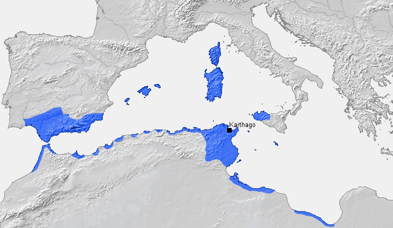
English: Location of Carthage and Carthaginian influence sphere before the First Punic War (264 BC) |
| Font |
Treball propi, based on Putzger Atlas und Chronik zur Weltgeschichte, Berlin, 2002 |
| Autor | BishkekRocks (discussió · contribucions) |
Llicència
| Jo, el titular del copyright d'aquesta obra, l'allibero al domini públic. Això s'aplica a tot el món. En alguns països això pot no ser legalment possible, en tal cas: Jo faig concessió a tothom del dret d'usar aquesta obra per a qualsevol propòsit, sense cap condició llevat d'aquelles requerides per la llei. |
Historial del fitxer
Cliqueu una data/hora per veure el fitxer tal com era aleshores.
| Data/hora | Miniatura | Dimensions | Usuari/a | Comentari | |
|---|---|---|---|---|---|
| actual | 17:32, 18 març 2006 | | 770 × 447 (106 Ko) | BishkekRocks | Location of Carthage and Carthaginian influence sphere before the First Punic War (264 BC) Source: Self-made, based on Putzger Atlas und Chronik zur Weltgeschichte, Berlin, 2002 Template: [http://www.demis.nl/wms/mapclip.htm] Author: ~~~ [[Category:Ca |
Ús del fitxer
Les 2 pàgines següents utilitzen aquest fitxer:
Ús global del fitxer
Utilització d'aquest fitxer en altres wikis:
- Utilització a als.wikipedia.org
- Utilització a ar.wikipedia.org
- Utilització a ba.wikipedia.org
- Utilització a be.wikipedia.org
- Utilització a bg.wikipedia.org
- Utilització a de.wikipedia.org
- Utilització a de.wikibooks.org
- Utilització a eo.wikipedia.org
- Utilització a es.wikipedia.org
- Utilització a fa.wikipedia.org
- Utilització a fr.wikipedia.org
- Utilització a fy.wikipedia.org
- Utilització a ga.wikipedia.org
- Utilització a hu.wikipedia.org
- Utilització a hy.wikipedia.org
- Utilització a id.wikipedia.org
- Utilització a it.wikipedia.org
- Utilització a ja.wikipedia.org
- Utilització a ka.wikipedia.org
- Utilització a ku.wikipedia.org
- Utilització a la.wikipedia.org
- Utilització a lt.wikipedia.org
- Utilització a lv.wikipedia.org
- Utilització a rm.wikipedia.org
- Utilització a ru.wikipedia.org
- Utilització a sh.wikipedia.org
- Utilització a sk.wikipedia.org
- Utilització a sl.wikipedia.org
- Utilització a sr.wikipedia.org
- Utilització a sw.wikipedia.org
- Utilització a tt.wikipedia.org
- Utilització a uk.wikipedia.org
Vegeu més usos globals d'aquest fitxer.