
Fitxer:Dennis 2005-07-10 1615Z (alternate).jpg

Fitxer original (6.800 × 8.800 píxels, mida del fitxer: 9,37 Mo, tipus MIME: image/jpeg)
| Aquest fitxer i la informació mostrada a continuació provenen del dipòsit multimèdia lliure Wikimedia Commons. |
| Atenció | El fitxer original té una quantitat elevada de píxels; si l’obriu a resolució plena, és possible que no es carregui correctament o provoqui que el vostre navegador es bloqui. Feu servir el ZoomViewer per a evitar aquests problemes. |
|---|
Resum
| Descripció |
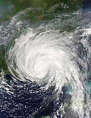
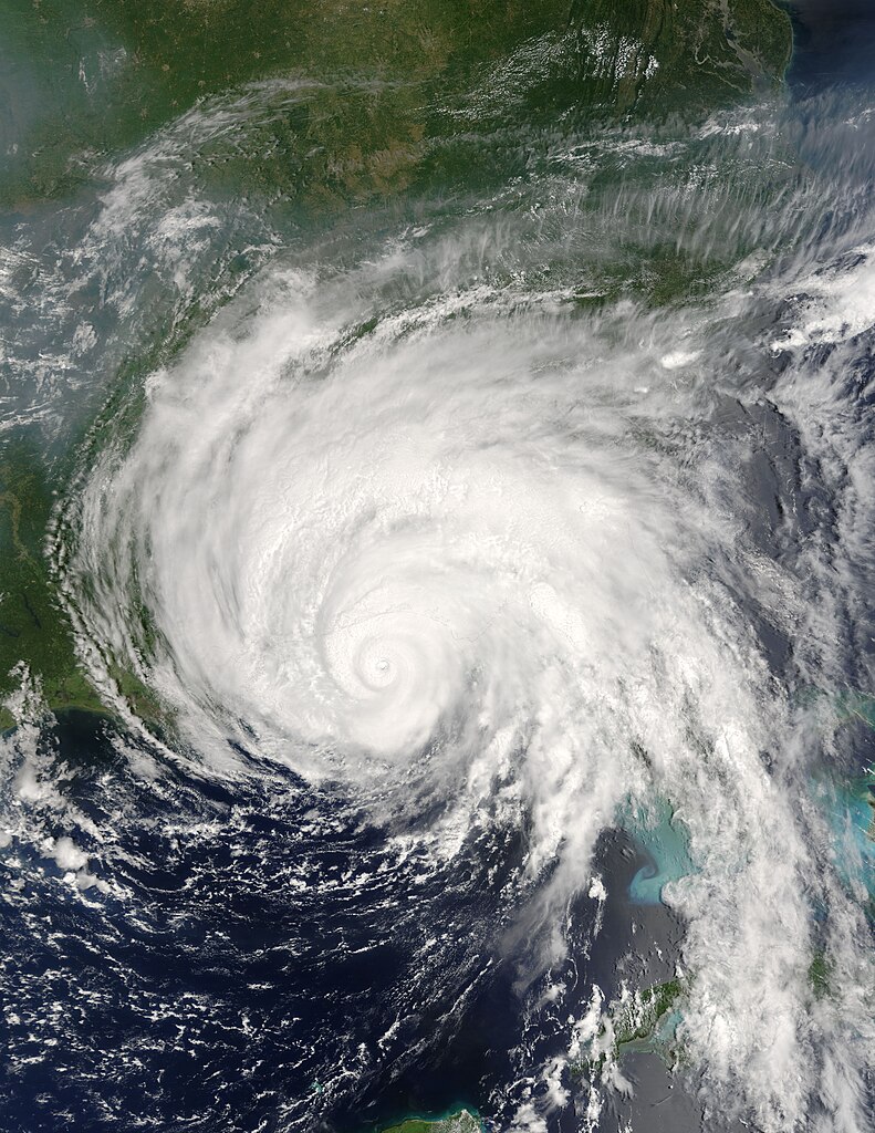
Hurricane Dennis was bearing down on the Gulf Coast of the United States on July 10, 2005, at 12:15 p.m. (16:15 UTC) when the Moderate Resolution Imaging Spectroradiometer on NASA's Terra satellite captured this image. With winds of 140 miles per hour (225 kph), Dennis was a powerful Category 4 storm just hours away from making landfall. At the time this image was taken, the eye of the storm was about 55 miles (90 kilometers) south, southeast of Pensacola, Florida, and the storm was moving northwest at about 18 miles per hour (29 kph). The size of the storm put clouds of rain over most of the southeastern United States well before the storm came ashore. In this image, Dennis covers all of Florida, Alabama, Mississippi, and stretches over parts of Louisiana. The northern fringes of the storm appear to be over Tennessee and North Carolina. For additional information and warnings about this storm, please visit the National Hurricane Center. This image is available in additional resolutions from the MODIS Rapid Response Team. |
|||||
| Data | ||||||
| Font | http://earthobservatory.nasa.gov/NaturalHazards/natural_hazards_v2.php3?img_id=12947 | |||||
| Autor | NASA image courtesy Jacques Descloitres, MODIS Rapid Response Team, NASA GSFC | |||||
| Permís (Com reutilitzar aquest fitxer) |
|
|||||
| Altres versions | Image:Hurricane Dennis 7102005.jpg |

.jpg?uselang=ca)
Historial del fitxer
Cliqueu una data/hora per veure el fitxer tal com era aleshores.
| Data/hora | Miniatura | Dimensions | Usuari/a | Comentari | |
|---|---|---|---|---|---|
| actual | 03:20, 22 oct 2006 | | 6.800 × 8.800 (9,37 Mo) | Good kitty | == Summary == {{Information |Description=Hurricane Dennis was bearing down on the Gulf Coast of the United States on July 10, 2005, at 12:15 p.m. (16:15 UTC) when the Moderate Resolution Imaging Spectroradiometer on NASA's Terra satellite captured this im |
Ús del fitxer
La pàgina següent utilitza aquest fitxer:
Ús global del fitxer
Utilització d'aquest fitxer en altres wikis:
- Utilització a ar.wikipedia.org
- Utilització a en.wikipedia.org
- Hurricane Dennis
- Timeline of the 2005 Atlantic hurricane season
- Portal:Cuba/Did you know
- Portal:Cuba/Did you know/9
- List of the wettest tropical cyclones in the United States
- Effects of Hurricane Dennis in Florida
- Effects of Hurricane Dennis in Alabama
- Effects of Hurricane Dennis in Georgia
- Effects of Hurricane Dennis in Mississippi
- Portal:Tropical cyclones/Featured article/Effects of Hurricane Dennis in Florida
- Template:Hurricane Dennis series
- List of natural disasters in Haiti
- Effects of Hurricane Dennis in Jamaica
- User:IPhonehurricane95/Picture of the day/Hurricane Dennis
- Meteorological history of Hurricane Dennis
- Effects of Hurricane Dennis in Haiti
- Utilització a es.wikipedia.org
- Utilització a eu.wikipedia.org
- Utilització a fr.wikipedia.org
- Utilització a ht.wikipedia.org
- Utilització a hu.wikipedia.org
- Utilització a no.wikipedia.org
- Utilització a pl.wikipedia.org
- Utilització a pt.wikipedia.org
- Utilització a ro.wikipedia.org
- Utilització a simple.wikipedia.org
- Utilització a sv.wikipedia.org
- Utilització a www.wikidata.org
- Utilització a zh.wikipedia.org
.jpg)