
Fitxer:Hurricane Erika 2003 Radar.jpg
No hi ha cap versió amb una resolució més gran.
Hurricane_Erika_2003_Radar.jpg (700 × 554 píxels, mida del fitxer: 376 Ko, tipus MIME: image/jpeg)
| Aquest fitxer i la informació mostrada a continuació provenen del dipòsit multimèdia lliure Wikimedia Commons. |
Resum
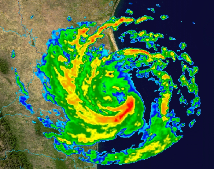
| Descripció | This image shows Hurricane Erika at 4:59 a.m. CDT on August 16, 2003, as it neared its landfall in Mexico. The foreground image is reflectivity data from the NWS NEXRAD radar at Brownsville, Texas; which is the black dot to the north of the center of the image. The background is true colour imagery derived from NASA's MODIS satellites. | ||
| Data | |||
| Font | Radar data from the NCDC NEXRAD database. Background image is NASA Blue Marble imagery. | ||
| Autor | Composite created by Nilfanion. | ||
| Permís (Com reutilitzar aquest fitxer) |
|
Historial del fitxer
Cliqueu una data/hora per veure el fitxer tal com era aleshores.
| Data/hora | Miniatura | Dimensions | Usuari/a | Comentari | |
|---|---|---|---|---|---|
| actual | 23:56, 16 oct 2006 | | 700 × 554 (376 Ko) | Nilfanion | {{Information |Description=This image shows Hurricane Erika at 4:59 a.m. CDT on August 16, 2003, as it neared its landfall in Mexico. The foreground image is reflectivity data from the NWS NEXRAD radar at Brownsville, Texas; which is the black dot to the |
Ús del fitxer
La pàgina següent utilitza aquest fitxer:
Ús global del fitxer
Utilització d'aquest fitxer en altres wikis:
- Utilització a en.wikipedia.org
- Utilització a eo.wikipedia.org
- Utilització a es.wikipedia.org
- Utilització a fi.wikipedia.org
- Utilització a simple.wikipedia.org
- Utilització a sv.wikipedia.org
- Utilització a zh.wikipedia.org