
Fitxer:Pechora.jpg

Mida d'aquesta previsualització: 463 × 599 píxels. Altres resolucions: 185 × 240 píxels | 371 × 480 píxels | 593 × 768 píxels | 791 × 1.024 píxels | 1.700 × 2.200 píxels.
Fitxer original (1.700 × 2.200 píxels, mida del fitxer: 803 Ko, tipus MIME: image/jpeg)
| Aquest fitxer i la informació mostrada a continuació provenen del dipòsit multimèdia lliure Wikimedia Commons. |
Resum
| Descripció |
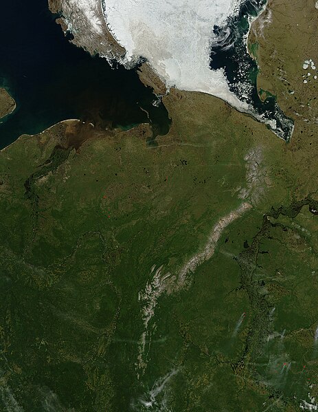
English: Pechora River
sattelite photo On July 3, 2004, sea ice still covered much of the Kara Sea in Northeastern Russia, near the western edge of Siberia, when the Moderate Resolution Imaging Spectroradiometer (MODIS) on NASA’s Aqua satellite captured this image. The southern tip of Novaya Zemlya Island curves out of the upper left corner of the image and is separated from Vaygach Island by Karskiye Vorota Strait. The narrow Yugorskiy Shar Strait, which separates Vaygach Island from mainland Russia, is clogged with sea ice. To the west, image left, the Pechora River is emptying brown, sediment-rich water into the Pechorskoye Sea. The water is probably loaded with mud as the far north thaws for the summer. In the lower right corner of the image, MODIS has detected a handful of fires, marked in red, which are sending light plumes of smoke to the southwest. |
| Font | Treball propi |
| Autor | user:Svart |
Llicència
| Aquest fitxer és en el domini públic perquè ha estat creat per la NASA. L'avís legal de la NASA diu que «el material de la NASA no està protegit per copyright si no es diu el contrari». (NASA copyright policy page o JPL Image Use Policy). | ||
 |
Atenció:
|
Historial del fitxer
Cliqueu una data/hora per veure el fitxer tal com era aleshores.
| Data/hora | Miniatura | Dimensions | Usuari/a | Comentari | |
|---|---|---|---|---|---|
| actual | 23:47, 27 març 2006 | | 1.700 × 2.200 (803 Ko) | Svart~commonswiki | '''Pechora River''' sattelite photo On July 3, 2004, sea ice still covered much of the Kara Sea in Northeastern Russia, near the western edge of Siberia, when the Moderate Resolution Imaging Spectroradiometer (MODIS) on NASA’s Aqua satellite captured |
Ús del fitxer
Les 5 pàgines següents utilitzen aquest fitxer:
Ús global del fitxer
Utilització d'aquest fitxer en altres wikis:
- Utilització a af.wikipedia.org
- Utilització a ar.wikipedia.org
- Utilització a arz.wikipedia.org
- Utilització a ast.wikipedia.org
- Utilització a az.wikipedia.org
- Utilització a be.wikipedia.org
- Utilització a bg.wikipedia.org
- Utilització a bn.wikipedia.org
- Utilització a ceb.wikipedia.org
- Utilització a ce.wikipedia.org
- Utilització a de.wikivoyage.org
- Utilització a diq.wikipedia.org
- Utilització a en.wikipedia.org
- Utilització a eo.wikipedia.org
- Utilització a es.wikipedia.org
- Utilització a eu.wikipedia.org
- Utilització a fi.wikipedia.org
- Utilització a fr.wikivoyage.org
- Utilització a ga.wikipedia.org
- Utilització a gl.wikipedia.org
- Utilització a he.wikipedia.org
- Utilització a hy.wikipedia.org
- Utilització a id.wikipedia.org
- Utilització a lmo.wikipedia.org
- Utilització a lv.wikipedia.org
- Utilització a mhr.wikipedia.org
- Utilització a mrj.wikipedia.org
- Utilització a myv.wikipedia.org
- Utilització a mzn.wikipedia.org
- Utilització a nn.wikipedia.org
Vegeu més usos globals d'aquest fitxer.