Vés al contingut

Fitxer:Blooming Waters off Argentina - NASA Earth Observatory.jpg

El contingut de la pàgina no s'admet en altres llengües.
De la Viquipèdia, l'enciclopèdia lliure

Fitxer original (720 × 720 píxels, mida del fitxer: 158 Ko, tipus MIME: image/jpeg)

Descripció a Commons

Resum

Descripció

To download the full resolution and other files go to: earthobservatory.nasa.gov/IOTD/view.php?id=76401&src=...

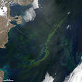
On a sunny spring day in November 2011, the clouds parted over coastal Argentina to reveal a massive bloom of phytoplankton coloring the ocean. Phytoplankton are microscopic, plant-like organisms that harness sunlight to turn carbon dioxide and water into sugars and oxygen (photosynthesis). They are the primary producers of the ocean and the center of the marine food web, providing food for everything from zooplankton to whales.

The Moderate Resolution Imaging Spectroradiometer (MODIS) on NASA’s Aqua satellite captured this natural-color image on November 5, 2011. The milky blue and green swirls are evidence of the abundant growth of phytoplankton across hundreds of kilometers of the sea.

These organisms contain pigments (such as chlorophyll) that appear in varying shades of blues, greens, and reds depending on the species. The phytoplankton in the image are likely a blend of diatoms, dinoflagellates, and coccolithophores. Blooms of diatoms and dinoflagellates are more common in the spring, while coccolithophores tend to dominate in early summer.

The blooms develop frequently in southern spring and summer at an intersection of two great current systems. The warm salty waters of the subtropical Brazil Current flow south and mix with colder, fresher waters that originate in the Southern Ocean and get carried northward by the Malvinas Current. Several major rivers, including the Rio de la Plata, carry nitrogen and iron-rich sediment from the continent into the sea, providing the nutrients needed for plant growth.
Data
Font Blooming Waters off Argentina
Autor NASA's Earth Observatory
Permís
(Com reutilitzar aquest fitxer)
NASA image by Jeff Schmaltz, LANCE/EOSDIS MODIS Rapid Response. Caption by Jeff Schmaltz and Mike Carlowicz.
Posició de la càmera43° 26′ 13,07″ S, 64° 00′ 22,85″ O Kartographer map based on OpenStreetMap.Aquesta i altres imatges properes a: OpenStreetMapinfo

Llicència

w:ca:Creative Commons
reconeixement
Aquest fitxer està disponible sota la llicència Creative Commons Reconeixement 2.0 Genèrica.
Sou lliure de:
  • compartir – copiar, distribuir i comunicar públicament l'obra
  • adaptar – fer-ne obres derivades
Amb les condicions següents:
  • reconeixement – Heu de donar la informació adequada sobre l'autor, proporcionar un enllaç a la llicència i indicar si s'han realitzat canvis. Podeu fer-ho amb qualsevol mitjà raonable, però de cap manera no suggereixi que l'autor us dóna suport o aprova l'ús que en feu.
This image was originally posted to Flickr by NASA Earth Observatory at https://www.flickr.com/photos/68824346@N02/6350775484. It was reviewed on 2 de juliol de 2012 by FlickreviewR and was confirmed to be licensed under the terms of the cc-by-2.0.

2 de juliol de 2012

Llegendes

Afegeix una explicació d'una línia del que representa aquest fitxer

Elements representats en aquest fitxer

representa l'entitat

43°26'13.074"S, 64°0'22.849"W

161.721 byte

720 píxel

720 píxel

Historial del fitxer

Cliqueu una data/hora per veure el fitxer tal com era aleshores.

Data/horaMiniaturaDimensionsUsuari/aComentari
actual18:19, 2 jul 2012Miniatura per a la versió del 18:19, 2 jul 2012720 × 720 (158 Ko)Dzlinker== {{int:filedesc}} == {{Information |Description=To download the full resolution and other files go to: [http://earthobservatory.nasa.gov/IOTD/view.php?id=76401&src=flickr earthobservatory.nasa.gov/IOTD/view.php?id=76401&src=...] On a sunny spring da...

La pàgina següent utilitza aquest fitxer:

Metadades