Vés al contingut

Fitxer:COVID-19 Outbreak America Map.svg

El contingut de la pàgina no s'admet en altres llengües.
De la Viquipèdia, l'enciclopèdia lliure

Fitxer original (fitxer SVG, nominalment 1.064 × 1.201 píxels, mida del fitxer: 529 Ko)

Descripció a Commons
This image should always reflect the most recent version. Feel free to update it when needed.
This file may be updated to reflect new information.
If you wish to use a specific version of the file without it being overwritten, please upload the required version as a separate file.

Resum

Descripció
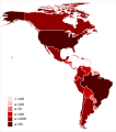
English (en): Map of the COVID-19 outbreak as of 13 April 2020 in America. Be aware that since this is a rapidly evolving situation, new cases may not be immediately represented visually. Refer to the primary article Pandemia de enfermedad por coronavirus de 2020 en América or the World Health Organization's situation reports for most recent reported case information.
 
1,000,000+ Confirmed cases
 
100,000–999,999 Confirmed cases
 
10,000–99999 Confirmed cases
 
1000–9999 Confirmed cases
 
100–999 Confirmed cases
 
1-99 Confirmed cases
Data
Font
 
This SVG _?_ includes elements that have been taken or adapted from this _?_:
Latinameriko.svg.
Data derived from Coronavirus COVID-19 Global Cases by the Center for Systems Science and Engineering (CSSE) at Johns Hopkins University (JHU)
Autor Basque mapping
SVG genesis
InfoField
 
El codi font d’aquest SVG no és vàlid perquè hi 5 han errors.
 
Aquesta imatge vectorial ha estat creada amb Inkscape.
 
 This world map uses embedded text that can be easily translated using a text editor.

Llicència

Jo, el titular dels drets d'autor d'aquest treball, el public sota la següent llicència:
w:ca:Creative Commons
reconeixement compartir igual
This file is licensed under the Creative Commons Attribution-Share Alike 4.0 International license.
Sou lliure de:
  • compartir – copiar, distribuir i comunicar públicament l'obra
  • adaptar – fer-ne obres derivades
Amb les condicions següents:
  • reconeixement – Heu de donar la informació adequada sobre l'autor, proporcionar un enllaç a la llicència i indicar si s'han realitzat canvis. Podeu fer-ho amb qualsevol mitjà raonable, però de cap manera no suggereixi que l'autor us dóna suport o aprova l'ús que en feu.
  • compartir igual – Si modifiqueu, transformeu, o generareu amb el material, haureu de distribuir les vostres contribucions sota una llicència similar o una de compatible com l'original
Any autoconfirmed user can overwrite this file from the same source. Please ensure that overwrites comply with the guideline.

Llegendes

Afegeix una explicació d'una línia del que representa aquest fitxer
Map of COVID-19 infected countries and territories in America

Elements representats en aquest fitxer

representa l'entitat

542.116 byte

1.201 píxel

1.064 píxel

Historial del fitxer

Cliqueu una data/hora per veure el fitxer tal com era aleshores.

Data/horaMiniaturaDimensionsUsuari/aComentari
actual19:13, 1 ago 2020Miniatura per a la versió del 19:13, 1 ago 20201.064 × 1.201 (529 Ko)Patrick N. Pozo PuertaUpdate
19:26, 13 abr 2020Miniatura per a la versió del 19:26, 13 abr 20201.064 × 1.201 (523 Ko)Basque mappingUpdate
12:56, 28 març 2020Miniatura per a la versió del 12:56, 28 març 20201.064 × 1.201 (523 Ko)Basque mappingUpdate
13:00, 22 març 2020Miniatura per a la versió del 13:00, 22 març 20201.064 × 1.201 (523 Ko)Basque mappingUpdate
13:04, 21 març 2020Miniatura per a la versió del 13:04, 21 març 20201.064 × 1.201 (523 Ko)Basque mappingUpdate
11:49, 20 març 2020Miniatura per a la versió del 11:49, 20 març 20201.064 × 1.201 (523 Ko)Basque mappingUpdate
17:43, 19 març 2020Miniatura per a la versió del 17:43, 19 març 20201.064 × 1.201 (523 Ko)Basque mappingUploaded own work with UploadWizard

No hi ha pàgines que utilitzin aquest fitxer.

Ús global del fitxer

Utilització d'aquest fitxer en altres wikis:

Metadades