
Fitxer:Cantinomap redsea persiangulf.jpg

Mida d'aquesta previsualització: 660 × 600 píxels. Altres resolucions: 264 × 240 píxels | 528 × 480 píxels | 666 × 605 píxels.
Fitxer original (666 × 605 píxels, mida del fitxer: 318 Ko, tipus MIME: image/jpeg)
| Aquest fitxer i la informació mostrada a continuació provenen del dipòsit multimèdia lliure Wikimedia Commons. |
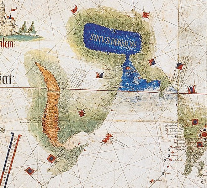
| Descripció | Enlarged detail showing Red Sea and Persian Gulf as viewed in 1502 in the Cantino World Map. Most important manuscript map surviving from the early Age of Discovery, the Cantino World Map is named for Alberto Cantino, an Italian diplomatic agent in Lisbon who obtained it in 1502 for the Duke of Ferrara. It incorporates extensive new geographical information based on four series of voyages: Columbus to the Caribbean, Pedro Álvarez Cabral to Brazil, Vasco de Gama followed by Cabral to eastern Africa and India, and the brothers Corte-Real to Greenland and Newfoundland. Except for Columbus, all had sailed under the Portuguese flag. |
| Data | (UTC) |
| Font | |
| Autor |
|
| Això és una imatge retocada, cosa que vol dir que ha estat alterada digitalment de la seva versió original. Modificacions: zoom in of Cantino map: the Red sea and Persian Golf. L'original es pot veure a: CantinoPlanisphere.png:
|
|
Això és una mera fotografia d'una obra d'art bidimensional en domini públic. L'obra d'art original és en domini públic pel següent motiu:
La posició oficial de la Fundació Wikimedia és que «les reproduccions fidels d'obres d'art bidimensionals de domini públic són en domini públic».
Per tant, aquesta reproducció fotogràfica també es considera en domini públic als Estats Units. En altres jurisdiccions la reutilització d'aquest contingut pot estar restringida; vegeu Reuse of PD-Art photographs per a més informació. | ||||
Registre original de càrregues
This image is a derivative work of the following images:
- File:CantinoPlanisphere.png licensed with PD-Art, PD-old
- 2007-07-01T05:35:29Z Tdmthomas 3528x1656 (12458523 Bytes) {{Information |Description=The most important manuscript map surviving from the early Age of Discovery, the Cantino World Map is named for Alberto Cantino, an Italian diplomatic agent in Lisbon who obtained it in 1502 for the
Uploaded with derivativeFX
Historial del fitxer
Cliqueu una data/hora per veure el fitxer tal com era aleshores.
| Data/hora | Miniatura | Dimensions | Usuari/a | Comentari | |
|---|---|---|---|---|---|
| actual | 15:39, 12 des 2009 | | 666 × 605 (318 Ko) | Uxbona | {{Information |Description= Enlarged detail showing Red Sea and Persian Gulf as viewed in 1502 in the Cantino World Map. Most important manuscript map surviving from the early Age of Discovery, the Cantino World Map is named for Alberto Cantino, an Italia |
Ús del fitxer
La pàgina següent utilitza aquest fitxer:
Ús global del fitxer
Utilització d'aquest fitxer en altres wikis:
- Utilització a ar.wikipedia.org
- Utilització a ckb.wikipedia.org
- Utilització a cs.wikipedia.org
- Utilització a de.wikipedia.org
- Utilització a el.wikipedia.org
- Utilització a en.wikipedia.org
- Utilització a es.wikipedia.org
- Utilització a fa.wikipedia.org
- Utilització a fr.wikipedia.org
- Utilització a it.wikipedia.org
- Utilització a mk.wikipedia.org
- Utilització a ms.wikipedia.org
- Utilització a pt.wikipedia.org
- Utilització a ru.wikipedia.org
- Utilització a uk.wikipedia.org
- Utilització a yi.wikipedia.org