Vés al contingut

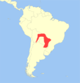
Fitxer:Cebus cay distribution.png

El contingut de la pàgina no s'admet en altres llengües.
De la Viquipèdia, l'enciclopèdia lliure

Fitxer original (1.314 × 1.377 píxels, mida del fitxer: 146 Ko, tipus MIME: image/png)

Descripció a Commons

Resum

Descripció
English: Geographic distribution of the Sapajus cay.
Data
Font

Put together by User:Miguelrangeljr using Corel Draw X6.

Autor Miguelrangeljr & IUCN (International Union for Conservation of Nature); see above
Permís
(Com reutilitzar aquest fitxer)
The use of spatial data from the IUCN Red List web site to produce species distribution maps is subject to the Attribution-Share Alike Creative Commons License. In short: you are free to distribute and modify the file as long as you attribute its authors and the IUCN Red List.

العربيَّة | English | español | français | македонски | മലയാളം | português | +/−

w:ca:Creative Commons
reconeixement compartir igual
Aquest fitxer està subjecte a la llicència de Creative Commons Reconeixement i Compartir Igual 3.0 No adaptada.
Reconeixement: IUCN Red List of Threatened Species, species assessors and the authors of the spatial data.
Sou lliure de:
  • compartir – copiar, distribuir i comunicar públicament l'obra
  • adaptar – fer-ne obres derivades
Amb les condicions següents:
  • reconeixement – Heu de donar la informació adequada sobre l'autor, proporcionar un enllaç a la llicència i indicar si s'han realitzat canvis. Podeu fer-ho amb qualsevol mitjà raonable, però de cap manera no suggereixi que l'autor us dóna suport o aprova l'ús que en feu.
  • compartir igual – Si modifiqueu, transformeu, o generareu amb el material, haureu de distribuir les vostres contribucions sota una llicència similar o una de compatible com l'original
VRT Wikimedia

El permís per utilitzar aquesta obra ha estat verificat i arxivat en el sistema VRT de Wikimedia.
Està disponible en el ticket #2010061810022172 per a usuaris registrats a VRTS. Per confirmar el permís, podeu posar-vos en contacte amb algú amb accés a VRTS.

Enllaç al ticket: https://ticket.wikimedia.org/otrs/index.pl?Action=AgentTicketZoom&TicketNumber=2010061810022172
Find other files from the same ticket: SDC query (SPARQL)

Llicència

The use of spatial data from the IUCN Red List web site to produce species distribution maps is subject to the Attribution-Share Alike Creative Commons License. In short: you are free to distribute and modify the file as long as you attribute its authors and the IUCN Red List.

العربيَّة | English | español | français | македонски | മലയാളം | português | +/−

w:ca:Creative Commons
reconeixement compartir igual
Aquest fitxer està subjecte a la llicència de Creative Commons Reconeixement i Compartir Igual 3.0 No adaptada.
Reconeixement: IUCN Red List of Threatened Species, species assessors and the authors of the spatial data.
Sou lliure de:
  • compartir – copiar, distribuir i comunicar públicament l'obra
  • adaptar – fer-ne obres derivades
Amb les condicions següents:
  • reconeixement – Heu de donar la informació adequada sobre l'autor, proporcionar un enllaç a la llicència i indicar si s'han realitzat canvis. Podeu fer-ho amb qualsevol mitjà raonable, però de cap manera no suggereixi que l'autor us dóna suport o aprova l'ús que en feu.
  • compartir igual – Si modifiqueu, transformeu, o generareu amb el material, haureu de distribuir les vostres contribucions sota una llicència similar o una de compatible com l'original
VRT Wikimedia

El permís per utilitzar aquesta obra ha estat verificat i arxivat en el sistema VRT de Wikimedia.
Està disponible en el ticket #2010061810022172 per a usuaris registrats a VRTS. Per confirmar el permís, podeu posar-vos en contacte amb algú amb accés a VRTS.

Enllaç al ticket: https://ticket.wikimedia.org/otrs/index.pl?Action=AgentTicketZoom&TicketNumber=2010061810022172
Find other files from the same ticket: SDC query (SPARQL)

Llegendes

Afegeix una explicació d'una línia del que representa aquest fitxer

Elements representats en aquest fitxer

representa l'entitat

149.685 byte

1.377 píxel

1.314 píxel

Historial del fitxer

Cliqueu una data/hora per veure el fitxer tal com era aleshores.

Data/horaMiniaturaDimensionsUsuari/aComentari
actual01:14, 18 juny 2013Miniatura per a la versió del 01:14, 18 juny 20131.314 × 1.377 (146 Ko)Miguelrangeljr{{Information |Description ={{en|1=Geographic distribution of the ''Sapajus cay''.}} |Source =Put together by User:Miguelrangeljr using Corel Draw X6. *Base map derived from File:Worldmap location NED 50m.svg (...
01:13, 18 juny 2013Miniatura per a la versió del 01:13, 18 juny 20131.314 × 1.377 (146 Ko)Miguelrangeljr{{Information |Description ={{en|1=Geographic distribution of the ''Sapajus cay''.}} |Source =Put together by User:Miguelrangeljr using Corel Draw X6. *Base map derived from File:Worldmap location NED 50m.svg (...

La pàgina següent utilitza aquest fitxer:

Ús global del fitxer

Utilització d'aquest fitxer en altres wikis:

Metadades