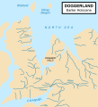
Fitxer:Doggerland.svg
Aparença

Mida d'aquesta previsualització PNG del fitxer SVG: 545 × 600 píxels. Altres resolucions: 218 × 240 píxels | 436 × 480 píxels | 698 × 768 píxels | 930 × 1.024 píxels | 1.860 × 2.048 píxels.
Fitxer original (fitxer SVG, nominalment 545 × 600 píxels, mida del fitxer: 165 Ko)
Historial del fitxer
Cliqueu una data/hora per veure el fitxer tal com era aleshores.
| Data/hora | Miniatura | Dimensions | Usuari/a | Comentari | |
|---|---|---|---|---|---|
| actual | 19:59, 19 oct 2014 |  | 545 × 600 (165 Ko) | Ras67 | frame removed |
| 14:06, 24 juny 2011 |  | 348 × 383 (132 Ko) | Ciaurlec | Changed colours to uniform all the palaeogeographic maps | |
| 01:52, 22 feb 2009 |  | 348 × 383 (125 Ko) | Maxí | {{Information |Description={{en|1=An image of the area known as Doggerland which connected the British Isles and the European continent. Loosely based on two images, found [http://www.bevpease.force9.co.uk/p.Flood_files/image002.jpg here] and [http://soga |
Ús del fitxer
La pàgina següent utilitza aquest fitxer:
Ús global del fitxer
Utilització d'aquest fitxer en altres wikis:
- Utilització a ar.wikipedia.org
- Utilització a arz.wikipedia.org
- Utilització a be.wikipedia.org
- Utilització a cs.wikipedia.org
- Utilització a cy.wikipedia.org
- Utilització a da.wikipedia.org
- Utilització a de.wikipedia.org
- Utilització a el.wikipedia.org
- Utilització a en.wikipedia.org
- Utilització a eo.wikipedia.org
- Utilització a es.wikipedia.org
- Utilització a et.wikipedia.org
- Utilització a eu.wikipedia.org
- Utilització a fa.wikipedia.org
- Utilització a fi.wikipedia.org
- Utilització a frr.wikipedia.org
- Utilització a fr.wikipedia.org
- Utilització a fr.wiktionary.org
- Utilització a glk.wikipedia.org
- Utilització a he.wikipedia.org
- Utilització a hr.wikipedia.org
- Utilització a hu.wikipedia.org
- Utilització a hy.wikipedia.org
Vegeu més usos globals d'aquest fitxer.


