
Fitxer:Extension of Germany (1935-1939)-es.svg

Mida d'aquesta previsualització PNG del fitxer SVG: 659 × 600 píxels. Altres resolucions: 264 × 240 píxels | 527 × 480 píxels | 844 × 768 píxels | 1.125 × 1.024 píxels | 2.250 × 2.048 píxels | 790 × 719 píxels.
Fitxer original (fitxer SVG, nominalment 790 × 719 píxels, mida del fitxer: 648 Ko)
| Aquest fitxer i la informació mostrada a continuació provenen del dipòsit multimèdia lliure Wikimedia Commons. |
| Descripció |
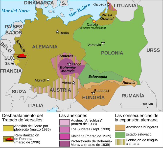
Español: Mapa de la extensión de Alemania (1935-1939) |
||||||||
| Data | |||||||||
| Font | Based on Image:Extension of Germany (1935-1939)-fr.svg | ||||||||
| Autor | JMPerez | ||||||||
| Permís (Com reutilitzar aquest fitxer) |
Jo, el titular dels drets d'autor d'aquest treball, el public sota les següents llicències:
Aquest fitxer està llicenciat sota les llicències de Creative Commons Reconeixement - CompartirIgual 2.5 Genèrica, 2.0 Genèrica i 1.0 Genèrica.
Podeu seleccionar la llicència que vulgueu. |
||||||||
| Altres versions |
Français : Carte en français Image:Extension of Germany (1935-1939)-fr.svg English: French version Image:Extension of Germany (1935-1939)-fr.svg |

-es.svg?uselang=ca)
-fr.svg)
-es.svg)
|
Aquest fitxer SVG inclou text encapsulat que es pot traduir al vostre idioma utilitzant un editor que admeti SVG, un editor de text o l'eina de traducció de SVG. Per a més informació vegeu l'ajuda de traducció de fitxers SVG. |
-es.svg)
Historial del fitxer
Cliqueu una data/hora per veure el fitxer tal com era aleshores.
| Data/hora | Miniatura | Dimensions | Usuari/a | Comentari | |
|---|---|---|---|---|---|
| actual | 21:01, 14 feb 2017 | | 790 × 719 (648 Ko) | Rowanwindwhistler | https://en.wikipedia.org/wiki/Wikipedia:WikiProject_Maps/Conventions Fake text added Múnich |
| 17:11, 5 set 2007 |  | 741 × 674 (116 Ko) | Redtony | "Prusia Oriental" traducido | |
| 17:38, 18 ago 2007 |  | 741 × 674 (116 Ko) | JMPerez~commonswiki | {{Information |Description={{es}}Mapa de la extensión de Alemania (1935-1939) |Source=Based on Image:Extension of Germany (1935-1939)-fr.svg |Date=18/08/2007 |Author=JMPerez |Permission={{self2|GFDL|cc-by-sa-2.5,2.0,1.0}} |other_ver |
-fr.svg)
Ús del fitxer
La pàgina següent utilitza aquest fitxer:
Ús global del fitxer
Utilització d'aquest fitxer en altres wikis:
- Utilització a ast.wikipedia.org
- Utilització a es.wikipedia.org
- Utilització a gl.wikipedia.org
-es.svg)