Fitxer:Eyjafjallajökull volcanic ash composite.png
Aparença

Mida d'aquesta previsualització: 600 × 600 píxels. Altres resolucions: 240 × 240 píxels | 480 × 480 píxels | 726 × 726 píxels.
Fitxer original (726 × 726 píxels, mida del fitxer: 95 Ko, tipus MIME: image/png)
Historial del fitxer
Cliqueu una data/hora per veure el fitxer tal com era aleshores.
| Data/hora | Miniatura | Dimensions | Usuari/a | Comentari | |
|---|---|---|---|---|---|
| actual | 15:53, 27 abr 2010 |  | 726 × 726 (95 Ko) | Cogiati | added 17 april |
| 15:09, 26 abr 2010 |  | 726 × 726 (93 Ko) | Cogiati | added 18 april | |
| 08:32, 26 abr 2010 |  | 726 × 726 (92 Ko) | Cogiati | added 25 April | |
| 17:00, 25 abr 2010 |  | 726 × 726 (91 Ko) | Cogiati | added 16 april | |
| 02:56, 25 abr 2010 |  | 726 × 726 (90 Ko) | Cogiati | added 20 april | |
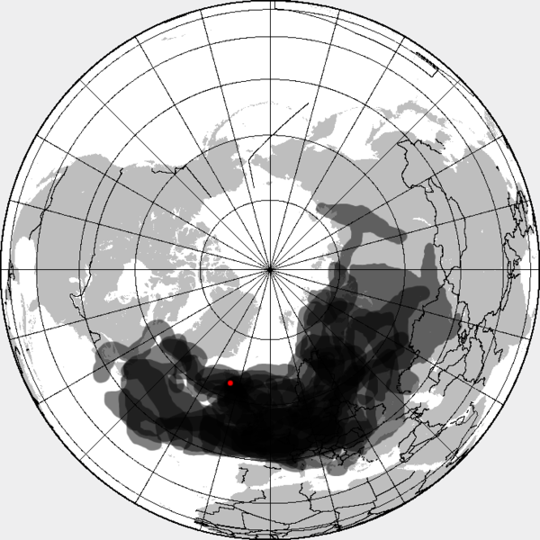
| 02:32, 25 abr 2010 |  | 726 × 726 (88 Ko) | Cogiati | {{Information |Description=This is a composite map showing the position of the Icelandinc volcanic ash cloud that closed European air space in different days. Based on maps found at http://www.metoffice.gov.uk/aviation/vaac/vaacuk_vag.html Days included: |
Ús del fitxer
La pàgina següent utilitza aquest fitxer:
Ús global del fitxer
Utilització d'aquest fitxer en altres wikis:
- Utilització a da.wikipedia.org
- Utilització a de.wikipedia.org
- Utilització a en.wikipedia.org
- Utilització a es.wikipedia.org
- Utilització a eu.wikipedia.org
- Utilització a fi.wikipedia.org
- Utilització a hu.wikipedia.org
- Utilització a it.wikipedia.org
- Utilització a ja.wikipedia.org
- Utilització a pnb.wikipedia.org
- Utilització a pt.wikipedia.org
- Utilització a ru.wikipedia.org
- Utilització a th.wikipedia.org
- Utilització a ur.wikipedia.org
- Utilització a vi.wikipedia.org
- Utilització a zh.wikipedia.org

