Vés al contingut

Fitxer:Germanic tribes (750BC-1AD).png

El contingut de la pàgina no s'admet en altres llengües.
De la Viquipèdia, l'enciclopèdia lliure

Germanic_tribes_(750BC-1AD).png (537 × 376 píxels, mida del fitxer: 10 Ko, tipus MIME: image/png)

Descripció a Commons

Resum

File:Germanic tribes settlements 750BC-1AD.svg és una versió vectorial (SVG) d'aquest fitxer. En cas de ser millor, hauria de ser emprada en lloc d'aquesta imatge tramada.

File:Germanic tribes (750BC-1AD).png → File:Germanic tribes settlements 750BC-1AD.svg

Per a més informació pel que fa als gràfics vectorials, llegiu la transició a SVG en Commons.
També hi ha informació quant a la compatibilitat del MediaWiki amb les imatges SVG.

En altres idiomes
Alemannisch  العربية  беларуская (тарашкевіца)  български  বাংলা  català  нохчийн  čeština  dansk  Deutsch  Ελληνικά  English  British English  Esperanto  español  eesti  euskara  فارسی  suomi  français  Frysk  galego  Alemannisch  עברית  hrvatski  magyar  հայերեն  Bahasa Indonesia  Ido  italiano  日本語  ქართული  한국어  lietuvių  македонски  മലയാളം  Bahasa Melayu  norsk bokmål  Plattdüütsch  Nederlands  norsk nynorsk  norsk  occitan  polski  prūsiskan  português  português do Brasil  română  русский  sicilianu  Scots  slovenčina  slovenščina  српски / srpski  svenska  தமிழ்  ไทย  Türkçe  татарча / tatarça  українська  vèneto  Tiếng Việt  中文  中文(中国大陆)  中文(简体)  中文(繁體)  中文(马来西亚)  中文(新加坡)  中文(臺灣)  中文(臺灣)  +/−
Nova imatge SVG

Descripció
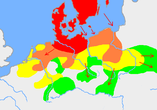
English: Based on p. 108 in the Penguin Atlas of World History, volume 1, from the Beginning to the Eve of the French Revolution. 1988. ISBN 0-14-051054-0. Note that the map assumes that the Nordwestblock was Germanized before 500 BC. This is uncertain; alternative proposals hold that the area near the mouths of the Rhine came under a Germanic superstate only in the 1st century BC.

The map is drawn on en:User:Dbachmann's blank map: en:Image:Europe plain rivers.png

 
Settlements before 750 bc
 
New settlements by 500 bc
 
New settlements by 250 bc
 
New settlements by ad 1
Archived copy of a version of the original map.
Data 21 de gener de 2007 (original upload date)
Font Transferred from en.wikipedia to Commons.
Autor Berig de la Viquipèdia en anglès

see also Image:Pre Migration Age Germanic.png

Llicència

I, Berig, el titular dels drets d'autor d'aquest treball, el public sota les següents llicències:
GNU head S'autoritza la còpia, la distribució i la modificació d'aquest document sota els termes de la llicència de documentació lliure GNU versió 1.2 o qualsevol altra versió posterior que publiqui la Free Software Foundation; sense seccions invariants, ni textos de portada, ni textos de contraportada. S'inclou una còpia d'aquesta llicència en la secció titulada GNU Free Documentation License.
w:ca:Creative Commons
reconeixement compartir igual
Aquest fitxer està subjecte a la llicència de Creative Commons Reconeixement i Compartir Igual 3.0 No adaptada.
Reconeixement: I, Berig
Sou lliure de:
  • compartir – copiar, distribuir i comunicar públicament l'obra
  • adaptar – fer-ne obres derivades
Amb les condicions següents:
  • reconeixement – Heu de donar la informació adequada sobre l'autor, proporcionar un enllaç a la llicència i indicar si s'han realitzat canvis. Podeu fer-ho amb qualsevol mitjà raonable, però de cap manera no suggereixi que l'autor us dóna suport o aprova l'ús que en feu.
  • compartir igual – Si modifiqueu, transformeu, o generareu amb el material, haureu de distribuir les vostres contribucions sota una llicència similar o una de compatible com l'original
Aquest avís de llicència s'ha afegit a aquest fitxer d'acord amb l'actualització de la llicència GFDL.
w:ca:Creative Commons
reconeixement
Aquest fitxer està disponible sota la llicència Creative Commons Reconeixement 2.5 Genèrica.
Reconeixement: I, Berig
Sou lliure de:
  • compartir – copiar, distribuir i comunicar públicament l'obra
  • adaptar – fer-ne obres derivades
Amb les condicions següents:
  • reconeixement – Heu de donar la informació adequada sobre l'autor, proporcionar un enllaç a la llicència i indicar si s'han realitzat canvis. Podeu fer-ho amb qualsevol mitjà raonable, però de cap manera no suggereixi que l'autor us dóna suport o aprova l'ús que en feu.
Podeu seleccionar la llicència que vulgueu.

Registre original de càrregues

La pàgina de descripció original era aquí. Els noms d'usuari a continuació es refereixen a en.wikipedia.
  • 2007-01-21 10:52 Berig 537×376×8 (18448 bytes) Based on p. 108 in the Penguin Atlas of World History, volume 1, from the Beginning to the Eve of the French Revolution. 1988. The map is drawn on [[User:Dbachmann]]'s blank map: [[:Image:Europe plain rivers.png]]

Llegendes

Afegeix una explicació d'una línia del que representa aquest fitxer
Approximation of Kinder's map of Germanic speaking peoples' expansion into Central Europe during the 1st millennium BC.

Elements representats en aquest fitxer

representa l'entitat

376 píxel

537 píxel

Historial del fitxer

Cliqueu una data/hora per veure el fitxer tal com era aleshores.

Data/horaMiniaturaDimensionsUsuari/aComentari
actual01:34, 17 feb 2009Miniatura per a la versió del 01:34, 17 feb 2009537 × 376 (10 Ko)Disposable.Heroespngcrush
18:17, 11 març 2007Miniatura per a la versió del 18:17, 11 març 2007537 × 376 (18 Ko)R9tgokunks{{Information |Description=Based on p. 108 in the Penguin Atlas of World History, volume 1, from the Beginning to the Eve of the French Revolution. 1988. ISBN 0-14-051054-0 The map is drawn on en:User:Dbachmann's blank map: [[:en::Image:Europe plain
21:17, 11 feb 2007Miniatura per a la versió del 21:17, 11 feb 2007537 × 376 (18 Ko)Electionworld{{Information |Description=Based on p. 108 in the Penguin Atlas of World History, volume 1, from the Beginning to the Eve of the French Revolution. 1988. ISBN 0-14-051054-0 The map is drawn on en:User:Dbachmann's blank map: [[:en::Image:Europe plain

Les 2 pàgines següents utilitzen aquest fitxer:

Ús global del fitxer

Utilització d'aquest fitxer en altres wikis:

Vegeu més usos globals d'aquest fitxer.

Metadades