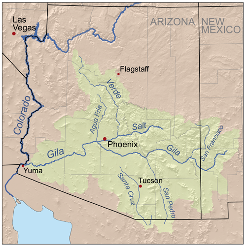
Fitxer:Gilarivermap.png
Aparença
Gilarivermap.png (499 × 500 píxels, mida del fitxer: 382 Ko, tipus MIME: image/png)
Historial del fitxer
Cliqueu una data/hora per veure el fitxer tal com era aleshores.
| Data/hora | Miniatura | Dimensions | Usuari/a | Comentari | |
|---|---|---|---|---|---|
| actual | 19:48, 13 set 2007 |  | 499 × 500 (382 Ko) | Kmusser | {{Information |Description=Map of the Gila River watershed. |Source=Self-made, based on USGS data. |Date=September 13, 2007 |Author= Kmusser }} {{self|cc-by-sa-2.5}} [[Category:Maps of rivers of the Unite |
Ús del fitxer
La pàgina següent utilitza aquest fitxer:
Ús global del fitxer
Utilització d'aquest fitxer en altres wikis:
- Utilització a af.wikipedia.org
- Utilització a bg.wikipedia.org
- Utilització a ceb.wikipedia.org
- Utilització a cs.wikipedia.org
- Utilització a de.wikipedia.org
- Utilització a en.wikipedia.org
- San Francisco River (Gila River tributary)
- Gila River
- Juan Bautista de Anza National Historic Trail
- User:Kmusser/Images
- List of tributaries of the Gila River
- Agua Fria River
- Category:Regions of Arizona
- San Pedro River (Arizona)
- Salt River Valley
- Centennial Wash (Maricopa County)
- East Verde River
- Category:Gila River
- List of longest rivers of the United States
- Utilització a es.wikipedia.org
- Utilització a et.wikipedia.org
- Utilització a fa.wikipedia.org
- Utilització a fi.wikipedia.org
- Utilització a fr.wikipedia.org
- Utilització a he.wikipedia.org
- Utilització a hy.wikipedia.org
- Utilització a id.wikipedia.org
- Utilització a it.wikipedia.org
- Utilització a ja.wikipedia.org
Vegeu més usos globals d'aquest fitxer.


