
Fitxer:Isle of Man TT Course (OpenStreetMap).svg

Mida d'aquesta previsualització PNG del fitxer SVG: 492 × 600 píxels. Altres resolucions: 197 × 240 píxels | 394 × 480 píxels | 630 × 768 píxels | 840 × 1.024 píxels | 1.681 × 2.048 píxels | 549 × 669 píxels.
Fitxer original (fitxer SVG, nominalment 549 × 669 píxels, mida del fitxer: 1,04 Mo)
| Aquest fitxer i la informació mostrada a continuació provenen del dipòsit multimèdia lliure Wikimedia Commons. |
.svg?uselang=ca)
| Descripció |
English:
Source: Open Street Map of the Isle of Man |
||||||||||||
| Data | |||||||||||||
| Font | OpenStreetMap | ||||||||||||
| Autor | Dan Karran | ||||||||||||
| Permís (Com reutilitzar aquest fitxer) |
Aquest fitxer està publicat sota la llicència de Creative Commons Reconeixement i Compartir Igual 2.0 Genèrica.
|
||||||||||||
| Altres versions | Isle of Man TT Course (OpenStreetMap).png | ||||||||||||
| SVG genesis |
.png)
| Posició de la càmera | | Aquesta i altres imatges properes a: OpenStreetMap |
|---|
.svg¶ms=054.229070_N_-004.445000_E_globe:Earth_type:camera__&language=ca)
Historial del fitxer
Cliqueu una data/hora per veure el fitxer tal com era aleshores.
| Data/hora | Miniatura | Dimensions | Usuari/a | Comentari | |
|---|---|---|---|---|---|
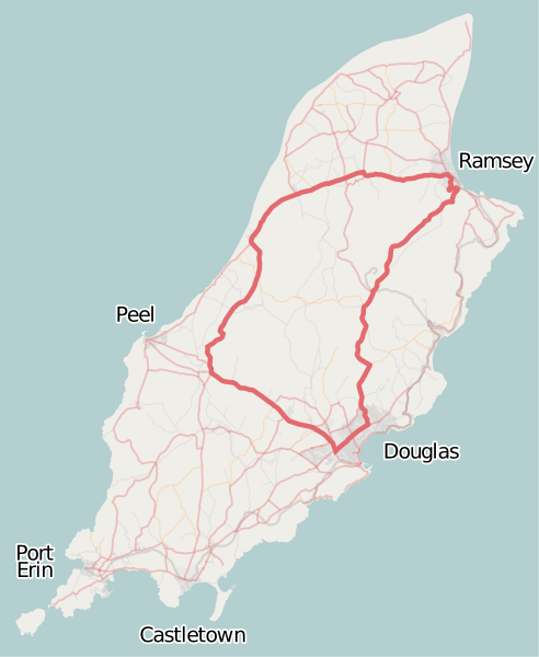
| actual | 18:43, 16 set 2008 | | 549 × 669 (1,04 Mo) | Dankarran | {{openstreetmap|name=Isle of Man}} {{Information |Description={{en|1= Overview map of the Isle of Man from OpenStreetMap project with the Snaefell mountain course course highlighted. Source: [http://www.openstreetmap.org/index.html?lat=54.22907&l |
| 10:40, 16 set 2008 |  | 549 × 669 (1,05 Mo) | Dankarran | {{Information |Description={{en|1={{openstreetmap|name=Isle of Man}} Overview map of the Isle of Man from OpenStreetMap project with the Snaefell mountain course course highlighted. Source: [http://www.openstreetmap.org/index.html?lat=54.22907&l | |
| 02:18, 16 set 2008 |  | 549 × 669 (1,05 Mo) | Dankarran | {{Information |Description={{en|1={{openstreetmap|name=Isle of Man}} Overview map of the Isle of Man from OpenStreetMap project with the Snaefell mountain course course highlighted. Source: [http://www.openstreetmap.org/index.html?lat=54.22907&l |
Ús del fitxer
Les 2 pàgines següents utilitzen aquest fitxer:
Ús global del fitxer
Utilització d'aquest fitxer en altres wikis:
- Utilització a de.wikipedia.org
- Utilització a en.wikipedia.org
- Isle of Man TT
- 2006 Isle of Man TT
- Manx Grand Prix
- 2005 Isle of Man TT
- 2002 Isle of Man TT
- 2000 Isle of Man TT
- 1996 Isle of Man TT
- 1995 Isle of Man TT
- Isle of Man TT Mountain Course
- 2007 Isle of Man TT
- 1949 Isle of Man TT
- 1954 Isle of Man TT
- 1955 Isle of Man TT
- 1952 Isle of Man TT
- 1956 Isle of Man TT
- 1960 Isle of Man TT
- 2008 Isle of Man TT
- List of Grand Prix motorcycle circuits
- 2009 Isle of Man TT
- 2010 Isle of Man TT
- 2011 Isle of Man TT
- 2012 Isle of Man TT
- 1976 Isle of Man TT
- 1977 Isle of Man TT
- 2013 Isle of Man TT
- 2014 Isle of Man TT
- List of named corners of the Snaefell Mountain Course
- 2016 Isle of Man TT
- 1975 Isle of Man TT
- 1986 Isle of Man TT
- 2019 Isle of Man TT
- 2023 Isle of Man TT
- 2022 Isle of Man TT
- 2018 Isle of Man TT
- 2017 Isle of Man TT
- 2015 Isle of Man TT
- 2004 Isle of Man TT
- 2003 Isle of Man TT
- 1999 Isle of Man TT
- 1998 Isle of Man TT
- 1997 Isle of Man TT
- 1992 Isle of Man TT
- 2024 Isle of Man TT
- Utilització a es.wikipedia.org
- Utilització a eu.wikipedia.org
- Utilització a id.wikipedia.org
Vegeu més usos globals d'aquest fitxer.
.svg)
.svg)