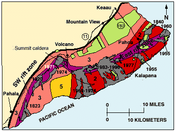
Fitxer:Kilauea Lava Hazard Map.gif
Aparença
Kilauea_Lava_Hazard_Map.gif (359 × 270 píxels, mida del fitxer: 18 Ko, tipus MIME: image/gif)
Historial del fitxer
Cliqueu una data/hora per veure el fitxer tal com era aleshores.
| Data/hora | Miniatura | Dimensions | Usuari/a | Comentari | |
|---|---|---|---|---|---|
| actual | 11:08, 27 maig 2010 |  | 359 × 270 (18 Ko) | Infanalyst | {{Information |Description={{en|1=Hazard zones for lava flows on Kilauea. The flows erupted since 1800 are shown in gray and dated. Twenty-eight percent of the area encompassed by Zones 1 and 2 on the east half of the volcano has been covered by lava sinc |
Ús del fitxer
La pàgina següent utilitza aquest fitxer:
Ús global del fitxer
Utilització d'aquest fitxer en altres wikis:
- Utilització a en.wikipedia.org
- Utilització a fr.wikipedia.org


