
Fitxer:LuxembourgPartitionsMap francais.jpg
No hi ha cap versió amb una resolució més gran.
LuxembourgPartitionsMap_francais.jpg (433 × 588 píxels, mida del fitxer: 111 Ko, tipus MIME: image/jpeg)
| Aquest fitxer i la informació mostrada a continuació provenen del dipòsit multimèdia lliure Wikimedia Commons. |

|
Aquesta imatge (de tipus historical map) s'hauria de tornar a crear utilitzant gràfics vectorials com ara un fitxer SVG. Això té diversos avantatges; en trobareu més informació a Commons:Media for cleanup. Si ja disposeu d'una versió d'aquesta imatge en format SVG, us preguem que la pengeu; després, reemplaceu aquesta plantilla amb la plantilla {{Vector version available|nom nou de la imatge.svg}} en aquesta imatge.
|


Resum
| Descripció |
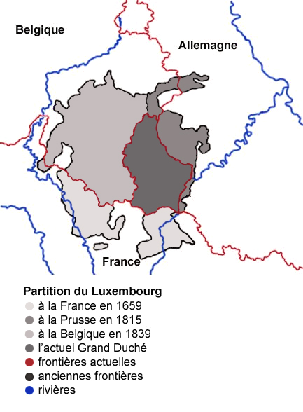
English: Map showing the partition of Luxembourg through the centuries, with French explanations.
Français : Carte montrant la partition du Luxembourg à travers les siècles. |
| Data | |
| Font |
|
| Autor | Spanish_Inquisition |
| Altres versions |
|


Llicència
| Jo, el titular del copyright d'aquesta obra, l'allibero al domini públic. Això s'aplica a tot el món. En alguns països això pot no ser legalment possible, en tal cas: Jo faig concessió a tothom del dret d'usar aquesta obra per a qualsevol propòsit, sense cap condició llevat d'aquelles requerides per la llei. |
Historial del fitxer
Cliqueu una data/hora per veure el fitxer tal com era aleshores.
| Data/hora | Miniatura | Dimensions | Usuari/a | Comentari | |
|---|---|---|---|---|---|
| actual | 11:11, 4 ago 2007 | | 433 × 588 (111 Ko) | Noelclem | |
| 10:22, 4 ago 2007 |  | 433 × 588 (101 Ko) | Noelclem | ||
| 17:40, 3 ago 2007 |  | 433 × 588 (49 Ko) | Iunity | correction orthographe | |
| 16:59, 3 set 2006 |  | 433 × 588 (85 Ko) | Spanish Inquisition | Map showing the partition of Luxembourg thorugh the centuries with french expanantions. Modification of the image LuxembourgPartitionsMap.png by user:QuartierLatin1968 14:10, 22 Apr 2005 (UTC). Author: user:Spanish_Inquisition Date: 3rd September 2006 |
Ús del fitxer
Les 2 pàgines següents utilitzen aquest fitxer:
Ús global del fitxer
Utilització d'aquest fitxer en altres wikis:
- Utilització a als.wikipedia.org
- Utilització a en.wikipedia.org
- Utilització a fr.wikipedia.org
- Luxembourg
- Histoire du Luxembourg
- Formation territoriale de la Belgique
- Frontière entre la France et le Luxembourg
- Wikipédia:Atelier graphique/Images à améliorer/Archives/Août 2007
- Frontière entre la Belgique et le Luxembourg
- Évolution territoriale du Luxembourg
- Frontières du Luxembourg
- Grand-duché de Luxembourg (1815-1890)
- Utilització a pcd.wikipedia.org
- Utilització a pl.wikipedia.org
- Utilització a pt.wikipedia.org
- Utilització a uk.wikipedia.org