
Fitxer:Luxembourg legislative election 2004 communes map.png
No hi ha cap versió amb una resolució més gran.
Luxembourg_legislative_election_2004_communes_map.png (203 × 270 píxels, mida del fitxer: 7 Ko, tipus MIME: image/png)
| Aquest fitxer i la informació mostrada a continuació provenen del dipòsit multimèdia lliure Wikimedia Commons. |
Resum
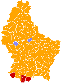
| Descripció | A map of the communes of Luxembourg (prior to the mergers of 1 January 2006) coloured by the plurality party in the 2004 election to the Chamber of Deputies. Orange represents the Christian Social People's Party, red represents the Luxembourg Socialist Workers' Party, and light blue represents the Democratic Party. |
| Data | |
| Font | Own work based on Image:Communes of Luxembourg.PNG. |
| Autor | Bastin |
| Permís (Com reutilitzar aquest fitxer) |
Released into the public domain. See licence below. |
Llicència
| Jo, el titular del copyright d'aquesta obra, l'allibero al domini públic. Això s'aplica a tot el món. En alguns països això pot no ser legalment possible, en tal cas: Jo faig concessió a tothom del dret d'usar aquesta obra per a qualsevol propòsit, sense cap condició llevat d'aquelles requerides per la llei. |
Historial del fitxer
Cliqueu una data/hora per veure el fitxer tal com era aleshores.
| Data/hora | Miniatura | Dimensions | Usuari/a | Comentari | |
|---|---|---|---|---|---|
| actual | 23:17, 1 març 2008 | | 203 × 270 (7 Ko) | Bastin8 | {{Information| |Description=A map of communes of Luxembourg after mergers of 2006-01-01, colour-coded by geographic area. Area is denoted by eight different shades of green; in order of increasingly darker shades, the lower bounds (in km²) are: 0, 10, 1 |
Ús del fitxer
La pàgina següent utilitza aquest fitxer:
Ús global del fitxer
Utilització d'aquest fitxer en altres wikis:
- Utilització a en.wikipedia.org
- Utilització a fi.wikipedia.org
- Utilització a fr.wikipedia.org
- Utilització a ru.wikipedia.org
- Utilització a www.wikidata.org