
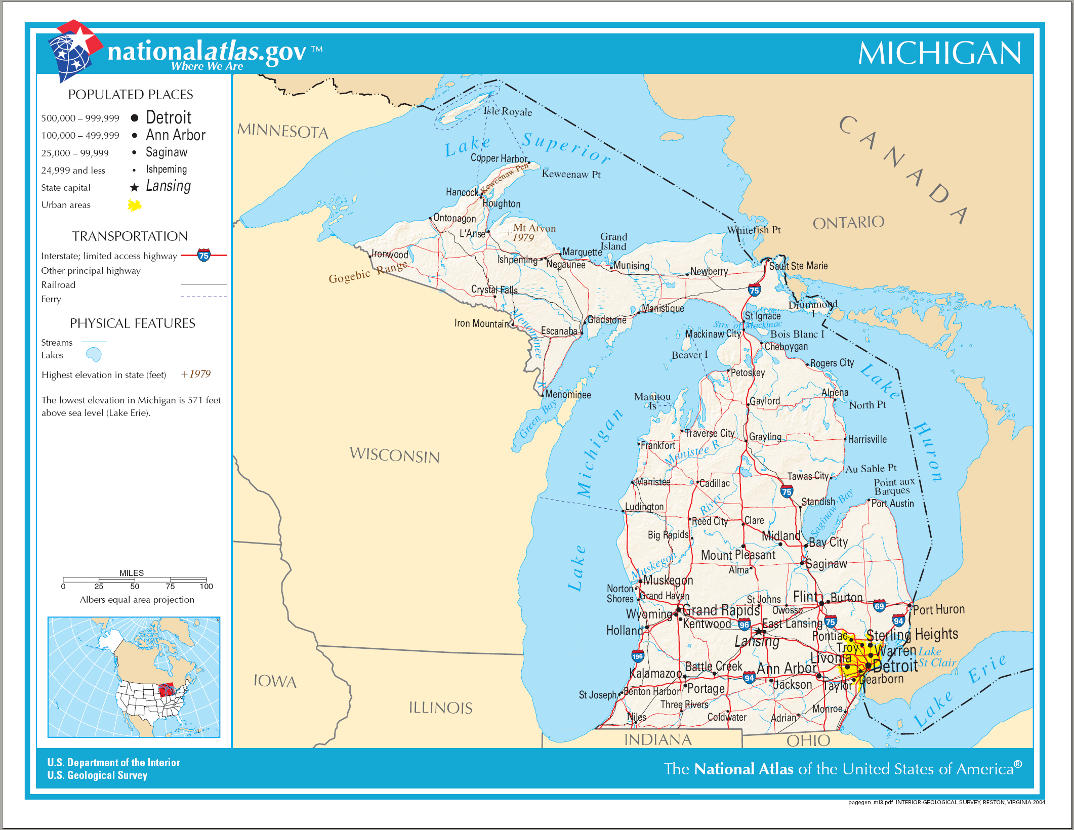
Fitxer:Map of Michigan NA.png
Mida d'aquesta previsualització: 776 × 600 píxels. Altres resolucions: 311 × 240 píxels | 621 × 480 píxels | 994 × 768 píxels | 1.280 × 989 píxels | 2.122 × 1.640 píxels.
Fitxer original (2.122 × 1.640 píxels, mida del fitxer: 1,21 Mo, tipus MIME: image/png)
| Aquest fitxer i la informació mostrada a continuació provenen del dipòsit multimèdia lliure Wikimedia Commons. |
Resum
| Descripció |
English: Map of Michigan |
| Data | |
| Font | National Atlas |
| Autor |
Llicència
This map was obtained from an edition of the National Atlas of the United States. Like almost all works of the U.S. federal government, works from the National Atlas are in the public domain in the United States.
Online access: NationalAtlas.gov | 1970 print edition: Library of Congress, Perry-Castañeda Library
|
Historial del fitxer
Cliqueu una data/hora per veure el fitxer tal com era aleshores.
| Data/hora | Miniatura | Dimensions | Usuari/a | Comentari | |
|---|---|---|---|---|---|
| actual | 23:09, 14 ago 2006 | | 2.122 × 1.640 (1,21 Mo) | Huebi~commonswiki | {{Information| |Description=Map of Michigan |Source=[http://www.nationalatlas.gov National Atlas] }} Category:Maps of the United States Category:Maps of Michigan {{PD-USGov-Atlas}} |
Ús del fitxer
Les 2 pàgines següents utilitzen aquest fitxer:
Ús global del fitxer
Utilització d'aquest fitxer en altres wikis:
- Utilització a de.wikipedia.org
- Utilització a en.wikipedia.org
- Utilització a fo.wikipedia.org
- Utilització a hr.wiktionary.org
- Utilització a hsb.wikipedia.org
- Utilització a ilo.wikipedia.org
- Utilització a incubator.wikimedia.org
- Utilització a it.wikipedia.org
- Utilització a kn.wikipedia.org
- Utilització a lij.wikipedia.org
- Utilització a ru.wikivoyage.org
- Utilització a simple.wikipedia.org
- Utilització a si.wikipedia.org
- Utilització a sl.wikipedia.org
- Utilització a sw.wikipedia.org
- Utilització a zea.wikipedia.org