
Fitxer:Map of the Hollywood Hills district of Los Angeles.png

Mida d'aquesta previsualització: 800 × 595 píxels. Altres resolucions: 320 × 238 píxels | 640 × 476 píxels | 827 × 615 píxels.
Fitxer original (827 × 615 píxels, mida del fitxer: 745 Ko, tipus MIME: image/png)
| Aquest fitxer i la informació mostrada a continuació provenen del dipòsit multimèdia lliure Wikimedia Commons. |
Resum
| Descripció |
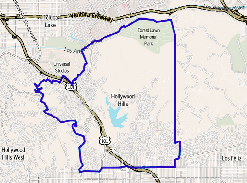
English: Map of Hollywood Hills as outlined by the Los Angeles Times
Boundary map as drawn by the Los Angeles Times on a CC-by-SA background. Note at bottom right of map on the L.A. Times website noted above says "CC-by-SA" (which gives permission to use the map). There is a link there to https://creativecommons.org/licenses/by-sa/2.0, which explains the meaning thereof. The base map is credited to http://www.openstreetmap.org/The Times spells all this out at http://projects.latimes.com/mapping-la/about/#the-data |
| Data | Data desconeguda |
| Font | http://projects.latimes.com/mapping-la/neighborhoods/neighborhood/hollywood-hills/ |
| Autor | Los Angeles Times |
| Permís (Com reutilitzar aquest fitxer) |
(Original text : http://projects.latimes.com/mapping-la/neighborhoods/neighborhood/hollywood-hills/) |
Llicència
Aquest fitxer està disponible sota la llicència Creative Commons Reconeixement 2.0 Genèrica.
- Sou lliure de:
- compartir – copiar, distribuir i comunicar públicament l'obra
- adaptar – fer-ne obres derivades
- Amb les condicions següents:
- reconeixement – Heu de donar la informació adequada sobre l'autor, proporcionar un enllaç a la llicència i indicar si s'han realitzat canvis. Podeu fer-ho amb qualsevol mitjà raonable, però de cap manera no suggereixi que l'autor us dóna suport o aprova l'ús que en feu.
Aquest fitxer està publicat sota la llicència de Creative Commons Reconeixement i Compartir Igual 1.0 Genèrica.
- Sou lliure de:
- compartir – copiar, distribuir i comunicar públicament l'obra
- adaptar – fer-ne obres derivades
- Amb les condicions següents:
- reconeixement – Heu de donar la informació adequada sobre l'autor, proporcionar un enllaç a la llicència i indicar si s'han realitzat canvis. Podeu fer-ho amb qualsevol mitjà raonable, però de cap manera no suggereixi que l'autor us dóna suport o aprova l'ús que en feu.
- compartir igual – If you alter, transform, or build upon this work, you must distribute the resulting work under the same license as the original.
Registre original de càrregues
La pàgina de descripció original era aquí. Els noms d'usuari a continuació es refereixen a en.wikipedia.
| Data/hora | Dimensions | Usuari/a | Comentari |
|---|---|---|---|
| 2013-05-24 00:34 | 827×615× (762586 bytes) | BeenAroundAWhile | Uploading a file from a free published source using [[Wikipedia:File_Upload_Wizard|File Upload Wizard]] |
Historial del fitxer
Cliqueu una data/hora per veure el fitxer tal com era aleshores.
| Data/hora | Miniatura | Dimensions | Usuari/a | Comentari | |
|---|---|---|---|---|---|
| actual | 02:33, 8 març 2016 | | 827 × 615 (745 Ko) | FastilyClone | Transferred from enwp |
Ús del fitxer
La pàgina següent utilitza aquest fitxer:
Ús global del fitxer
Utilització d'aquest fitxer en altres wikis:
- Utilització a ar.wikipedia.org
- Utilització a bn.wikipedia.org
- Utilització a en.wikipedia.org
- Utilització a eu.wikipedia.org
- Utilització a fa.wikipedia.org
- Utilització a fi.wikipedia.org
- Utilització a fr.wikipedia.org
- Utilització a hu.wikipedia.org
- Utilització a it.wikipedia.org
- Utilització a pl.wikipedia.org
- Utilització a pt.wikipedia.org
- Utilització a ro.wikipedia.org
- Utilització a ru.wikipedia.org
- Utilització a sco.wikipedia.org
- Utilització a sv.wikipedia.org
- Utilització a www.wikidata.org
- Utilització a zh.wikipedia.org