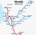
Fitxer:Marseille - Metro - Netzplan.png
Aparença

Mida d'aquesta previsualització: 620 × 599 píxels. Altres resolucions: 248 × 240 píxels | 496 × 480 píxels | 794 × 768 píxels | 1.059 × 1.024 píxels | 1.600 × 1.547 píxels.
Fitxer original (1.600 × 1.547 píxels, mida del fitxer: 198 Ko, tipus MIME: image/png)
Historial del fitxer
Cliqueu una data/hora per veure el fitxer tal com era aleshores.
| Data/hora | Miniatura | Dimensions | Usuari/a | Comentari | |
|---|---|---|---|---|---|
| actual | 21:12, 17 ago 2010 |  | 1.600 × 1.547 (198 Ko) | Chumwa | Aktualisierung 2010 |
| 08:29, 17 maig 2009 |  | 1.600 × 1.547 (203 Ko) | Chumwa | Schrift vergrößert | |
| 08:03, 17 maig 2009 |  | 1.600 × 1.547 (174 Ko) | Chumwa | {{Information |Description= *{{ de }} Karte: Netzplan der Metro Marseille, Stand Mai 2009 *{{ en }} Map: Marseille underground network as of May 2009 *{{ fr }} Plan: Réseau des métros de Marseille en Mai 2009 |Source=Self made |Date=May 2009 |Author= [[ |
Ús del fitxer
Les 2 pàgines següents utilitzen aquest fitxer:
Ús global del fitxer
Utilització d'aquest fitxer en altres wikis:
- Utilització a be.wikipedia.org
- Utilització a bn.wikipedia.org
- Utilització a de.wikivoyage.org
- Utilització a es.wikipedia.org
- Utilització a eu.wikipedia.org
- Utilització a fa.wikipedia.org
- Utilització a fi.wikipedia.org
- Utilització a hu.wikipedia.org
- Utilització a id.wikipedia.org
- Utilització a ka.wikipedia.org
- Utilització a ko.wikipedia.org
- Utilització a nl.wikipedia.org
- Utilització a pl.wikipedia.org
- Utilització a pl.wikivoyage.org
- Utilització a pt.wikipedia.org
- Utilització a ru.wikipedia.org
- Utilització a th.wikipedia.org
- Utilització a www.wikidata.org


