
Fitxer:Mediterranean Sea East location map.svg

Fitxer original (fitxer SVG, nominalment 957 × 765 píxels, mida del fitxer: 186 Ko)
| Aquest fitxer i la informació mostrada a continuació provenen del dipòsit multimèdia lliure Wikimedia Commons. |
Resum
| Descripció |
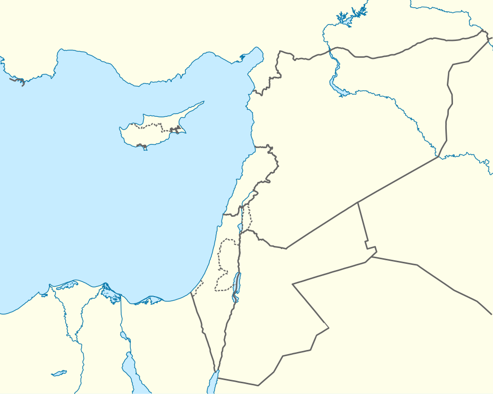
Deutsch: Positionskarte des östlichen Mittelmeers
Quadratische Plattkarte, N-S-Streckung 120 %. Geographische Begrenzung der Karte:
English: Location map of the Eastern Mediterranean Sea
Equirectangular projection, N/S stretching 120 %. Geographic limits of the map:
|
|
| Data | ||
| Font | Own work using: World Data Base II data | |
| Autor | NordNordWest | |
| Permís (Com reutilitzar aquest fitxer) |
Aquest fitxer està publicat sota la llicència de Creative Commons Reconeixement i Compartir Igual 3.0 Alemanya.
 |


|
This map has been made or improved in the German Kartenwerkstatt (Map Lab). You can propose maps to improve as well.
|
Llicència
- Sou lliure de:
- compartir – copiar, distribuir i comunicar públicament l'obra
- adaptar – fer-ne obres derivades
- Amb les condicions següents:
- reconeixement – Heu de donar la informació adequada sobre l'autor, proporcionar un enllaç a la llicència i indicar si s'han realitzat canvis. Podeu fer-ho amb qualsevol mitjà raonable, però de cap manera no suggereixi que l'autor us dóna suport o aprova l'ús que en feu.
- compartir igual – Si modifiqueu, transformeu, o generareu amb el material, haureu de distribuir les vostres contribucions sota una llicència similar o una de compatible com l'original
Historial del fitxer
Cliqueu una data/hora per veure el fitxer tal com era aleshores.
| Data/hora | Miniatura | Dimensions | Usuari/a | Comentari | |
|---|---|---|---|---|---|
| actual | 19:28, 3 abr 2013 | | 957 × 765 (186 Ko) | NordNordWest | =={{int:filedesc}}== {{Information |Description= {{de|Positionskarte des östlichen Mittelmeers}} Quadratische Plattkarte, N-S-Streckung 120 %. Geographische Begrenzung der Karte: * N: 38.0° N * S: 29.0° N * W: 29.0° O * O: 42.5°... |
Ús del fitxer
Les 3 pàgines següents utilitzen aquest fitxer:
Ús global del fitxer
Utilització d'aquest fitxer en altres wikis:
- Utilització a ast.wikipedia.org
- Episkopí
- Acrotiri (pueblu)
- Nicosia
- Limasol
- Famagusta
- Módulu:Mapa de llocalización/datos/Xipre
- Módulu:Mapa de llocalización/datos/Xipre/usu
- Aeropuertu Internacional de Lárnaca
- Aeropuertu Internacional de Pafos
- Aeropuertu d'Ercan
- Aeropuertu de Nicosia
- Base Aérea de Geçitkale
- Puertu de Limasol
- Pelendri
- Kantou
- Mouttagiaka
- Paramali
- Platres
- Pano Polemidia
- Kato Kivides
- Pissouri
- Omodos
- Platanisteia
- Kolossi
- Kyperounta
- Foini
- Pachna
- Palodia
- Palaiomylos
- Pera Pedi
- Monagroulli
- Paramytha
- Pentakomo
- Parekklisia
- Moniatis
- Prastio (Avdimou)
- Potamitissa
- Potamiou
- Asgata
- Prodromos
- Trachoni
- Vouni
- Armenokhori
- Vikla
- Vasa Koilaniou
- Vasa Kellakiou
- Tserkezoi
- Trimiklini
- Treis Elies
- Sykopetra
Vegeu més usos globals d'aquest fitxer.