Vés al contingut

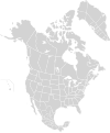
Fitxer:North America second level political division 2 and Greenland.svg

El contingut de la pàgina no s'admet en altres llengües.
De la Viquipèdia, l'enciclopèdia lliure

Fitxer original (fitxer SVG, nominalment 1.789 × 2.154 píxels, mida del fitxer: 367 Ko)

Descripció a Commons
Descripció
English: Map of North America and its second-level political divisions. Canadian provinces and territories, US and Mexican states. Canada, Mexico, United States.

Non-contiguous parts of a states/provinces are "grouped" together with the main area of the state/provinces, so any state/provinces can be coloured in completion with one click anywhere on the state/provinces's area.

Also, all states/provinces have a "id" attached to them, making them easy to find. Select "find" and then enter in the state/provinces's ISO 3166-2 code in the "id" field to find it. The codes can be found here (Canada), here (USA) and here (Mexico).
Data
Font

Canada and US map: BlankMap-USA-states-Canada-provinces, HI closer.svg by Lokal_Profil.
Mexico map: Mexico template.svg by Mario Fuente Cid
Greenland map: Image:Greenland.svg
Combined by Alex Covarrubias, Greenland added by carol.

 
El codi font d'aquest SVG és vàlid.
 
Aquesta imatge vectorial va ser creada amb Inkscape, i posteriorment modificada manualment
.
 
W3C-validity not checked.
Autor Alex Covarrubias
Permís
(Com reutilitzar aquest fitxer)
w:ca:Creative Commons
reconeixement compartir igual
Aquest fitxer està publicat sota la llicència de Creative Commons Reconeixement i Compartir Igual 2.5 Genèrica.
Sou lliure de:
  • compartir – copiar, distribuir i comunicar públicament l'obra
  • adaptar – fer-ne obres derivades
Amb les condicions següents:
  • reconeixement – Heu de donar la informació adequada sobre l'autor, proporcionar un enllaç a la llicència i indicar si s'han realitzat canvis. Podeu fer-ho amb qualsevol mitjà raonable, però de cap manera no suggereixi que l'autor us dóna suport o aprova l'ús que en feu.
  • compartir igual – Si modifiqueu, transformeu, o generareu amb el material, haureu de distribuir les vostres contribucions sota una llicència similar o una de compatible com l'original
Altres versions

Derivative works of this file:

Llegendes

Afegeix una explicació d'una línia del que representa aquest fitxer

Elements representats en aquest fitxer

representa l'entitat

Historial del fitxer

Cliqueu una data/hora per veure el fitxer tal com era aleshores.

Data/horaMiniaturaDimensionsUsuari/aComentari
actual14:57, 18 març 2008Miniatura per a la versió del 14:57, 18 març 20081.789 × 2.154 (367 Ko)CarolSpearsminor validation problems repaired
14:41, 18 març 2008Miniatura per a la versió del 14:41, 18 març 20081.789 × 2.154 (367 Ko)CarolSpears{{Information |Description={{en|Map of North America and its second-level political divisions. Canadian provinces, US and Mexican states. Canada, Mexico, United States. Non-contiguous parts of a states/provinces are "grouped" together with the main area

No hi ha pàgines que utilitzin aquest fitxer.

Ús global del fitxer