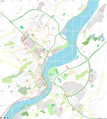
Fitxer:Open street map derry londonderry.png
Aparença

Mida d'aquesta previsualització: 537 × 600 píxels. Altres resolucions: 215 × 240 píxels | 430 × 480 píxels | 916 × 1.023 píxels.
Fitxer original (916 × 1.023 píxels, mida del fitxer: 654 Ko, tipus MIME: image/png)
Historial del fitxer
Cliqueu una data/hora per veure el fitxer tal com era aleshores.
| Data/hora | Miniatura | Dimensions | Usuari/a | Comentari | |
|---|---|---|---|---|---|
| actual | 20:38, 28 abr 2021 |  | 916 × 1.023 (654 Ko) | Sheila1988 | shaded the river blue |
| 22:18, 2 maig 2018 |  | 2.248 × 2.511 (1,78 Mo) | SpanishSnake | final window dimentions | |
| 18:48, 2 maig 2018 |  | 2.047 × 1.333 (1,34 Mo) | SpanishSnake | new map | |
| 13:59, 2 maig 2018 |  | 229 × 351 (91 Ko) | SpanishSnake | {{Information |description ={{en|1={{Open Street Map}}}} |source =https://www.openstreetmap.org |author =Open Street Map |date = }} Category:Maps of Derry |
Ús del fitxer
La pàgina següent utilitza aquest fitxer:
Ús global del fitxer
Utilització d'aquest fitxer en altres wikis:
- Utilització a en.wikipedia.org
- Bogside
- Ryan McBride Brandywell Stadium
- St Columb's Cathedral
- Celtic Park (Derry)
- Derry ~ Londonderry railway station
- Altnagelvin Area Hospital
- Enagh Lough
- St Eugene's Cathedral
- St Columba's Church, Long Tower
- Guildhall, Derry
- Module:Location map/data/United Kingdom Derry
- Module:Location map/data/United Kingdom Derry/doc
- Void Gallery
- Utilització a fr.wikipedia.org
- Utilització a ga.wikipedia.org
- Utilització a ja.wikipedia.org
- Utilització a si.wikipedia.org
- Utilització a uz.wikipedia.org
- Utilització a www.wikidata.org


