
Fitxer:Overview of the Gale Crater Landing Site.jpg

Mida d'aquesta previsualització: 430 × 600 píxels. Altres resolucions: 172 × 240 píxels | 344 × 480 píxels | 551 × 768 píxels | 734 × 1.024 píxels | 1.469 × 2.048 píxels | 3.856 × 5.376 píxels.
Fitxer original (3.856 × 5.376 píxels, mida del fitxer: 3,8 Mo, tipus MIME: image/jpeg)
| Aquest fitxer i la informació mostrada a continuació provenen del dipòsit multimèdia lliure Wikimedia Commons. |
Resum
| Descripció |
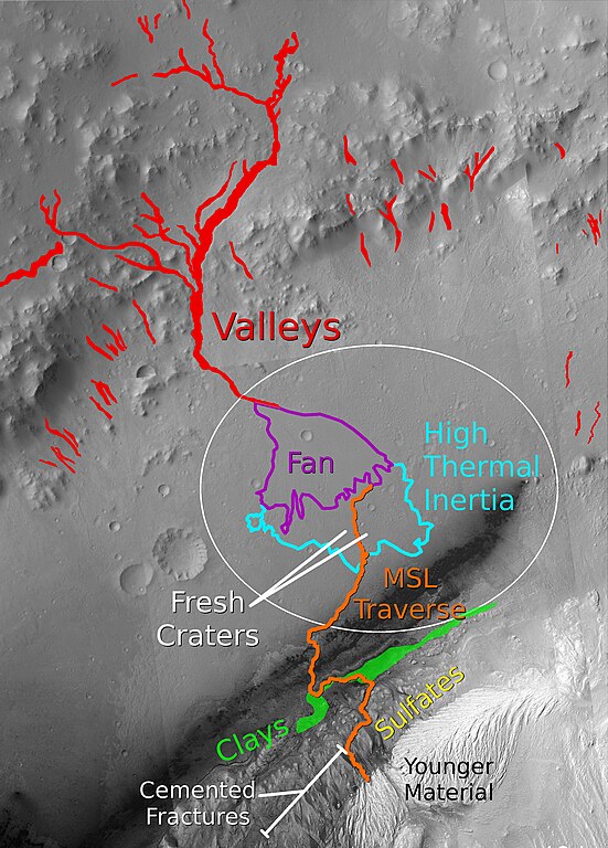
English: This graphic shows key features at the MSL landing site in Gale crater. A possible traverse path is shown in orange. Branching valleys from the crater wall lead to an alluvial fan in the center of the ellipse. At the end of the alluvial fan, the terrain transitions to a fractured, layered unit with a high thermal inertia. Several fresh craters in this unit are accessible. The primary target of the mission is the clay-bearing unit on the lower portion of the layered central mound, and its transition to the overlying sulfate-bearing layers. Cemented fractures in the sulfate-bearing rocks suggest groundwater interactions. A light-toned lens of younger material, heavily eroded by wind, marks the end of the notional traverse. |
| Data | |
| Font | The basemap for this image is a mosaic of images from the Context Camera (CTX) on the Mars Reconnaissance Orbiter (MRO). Clay and sulfate units are based on mineral parameter maps generated by Milliken et al., 2010 using data from the Compact Reconnaissance Imaging Spectrometer for Mars (CRISM) on MRO. Other units and features are adapted from Anderson and Bell, 2010 |
| Autor | Ryan Anderson |
Llicència
Jo, el titular dels drets d'autor d'aquest treball, el public sota la següent llicència:
Aquest fitxer està subjecte a la llicència de Creative Commons Reconeixement i Compartir Igual 3.0 No adaptada.
- Sou lliure de:
- compartir – copiar, distribuir i comunicar públicament l'obra
- adaptar – fer-ne obres derivades
- Amb les condicions següents:
- reconeixement – Heu de donar la informació adequada sobre l'autor, proporcionar un enllaç a la llicència i indicar si s'han realitzat canvis. Podeu fer-ho amb qualsevol mitjà raonable, però de cap manera no suggereixi que l'autor us dóna suport o aprova l'ús que en feu.
- compartir igual – Si modifiqueu, transformeu, o generareu amb el material, haureu de distribuir les vostres contribucions sota una llicència similar o una de compatible com l'original
Historial del fitxer
Cliqueu una data/hora per veure el fitxer tal com era aleshores.
| Data/hora | Miniatura | Dimensions | Usuari/a | Comentari | |
|---|---|---|---|---|---|
| actual | 04:41, 30 jul 2011 | | 3.856 × 5.376 (3,8 Mo) | RyanA1084 |
Ús del fitxer
La pàgina següent utilitza aquest fitxer:
Ús global del fitxer
Utilització d'aquest fitxer en altres wikis:
- Utilització a hr.wikipedia.org
- Utilització a ja.wikipedia.org
- Utilització a sr.wikipedia.org
- Utilització a zh.wikipedia.org