
Fitxer:Pascagoularivermap.png
No hi ha cap versió amb una resolució més gran.
Pascagoularivermap.png (467 × 467 píxels, mida del fitxer: 138 Ko, tipus MIME: image/png)
| Aquest fitxer i la informació mostrada a continuació provenen del dipòsit multimèdia lliure Wikimedia Commons. |
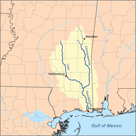
| Descripció | Map of the Pascagoula River watershed. |
| Data | |
| Font | Self-made, based on USGS data. |
| Autor | Kmusser |
Jo, el titular dels drets d'autor d'aquest treball, el public sota la següent llicència:
Aquest fitxer està publicat sota la llicència de Creative Commons Reconeixement i Compartir Igual 2.5 Genèrica.
- Sou lliure de:
- compartir – copiar, distribuir i comunicar públicament l'obra
- adaptar – fer-ne obres derivades
- Amb les condicions següents:
- reconeixement – Heu de donar la informació adequada sobre l'autor, proporcionar un enllaç a la llicència i indicar si s'han realitzat canvis. Podeu fer-ho amb qualsevol mitjà raonable, però de cap manera no suggereixi que l'autor us dóna suport o aprova l'ús que en feu.
- compartir igual – Si modifiqueu, transformeu, o generareu amb el material, haureu de distribuir les vostres contribucions sota una llicència similar o una de compatible com l'original
Historial del fitxer
Cliqueu una data/hora per veure el fitxer tal com era aleshores.
| Data/hora | Miniatura | Dimensions | Usuari/a | Comentari | |
|---|---|---|---|---|---|
| actual | 23:10, 29 abr 2007 | | 467 × 467 (138 Ko) | DanMS | Trimmed excess white space around image and uploaded same again. |
| 19:23, 24 abr 2007 |  | 500 × 500 (148 Ko) | Kmusser | {{Information |Description=Map of the Pascagoula River watershed. |Source=Self-made, based on USGS data. |Date=April 24, 2007 |Author= Kmusser }} {{self|cc-by-sa-2.5}} [[Category:Maps of rivers of the |
Ús del fitxer
La pàgina següent utilitza aquest fitxer:
Ús global del fitxer
Utilització d'aquest fitxer en altres wikis:
- Utilització a arz.wikipedia.org
- Utilització a bg.wikipedia.org
- Utilització a ceb.wikipedia.org
- Utilització a cv.wikipedia.org
- Utilització a da.wikipedia.org
- Utilització a de.wikipedia.org
- Utilització a en.wikipedia.org
- Utilització a es.wikipedia.org
- Utilització a fr.wikipedia.org
- Utilització a kk.wikipedia.org
- Utilització a ms.wikipedia.org
- Utilització a no.wikipedia.org
- Utilització a ru.wikipedia.org
- Utilització a sr.wikipedia.org
- Utilització a th.wikipedia.org
- Utilització a vi.wikipedia.org
- Utilització a www.wikidata.org
- Utilització a zh.wikipedia.org