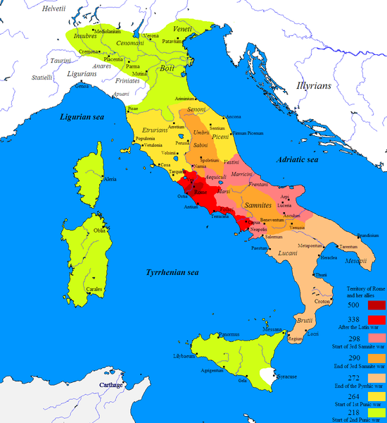
Fitxer:Roman conquest of Italy.PNG
Aparença

Mida d'aquesta previsualització: 550 × 600 píxels. Altres resolucions: 220 × 240 píxels | 440 × 480 píxels | 704 × 768 píxels | 1.100 × 1.200 píxels.
Fitxer original (1.100 × 1.200 píxels, mida del fitxer: 125 Ko, tipus MIME: image/png)
Historial del fitxer
Cliqueu una data/hora per veure el fitxer tal com era aleshores.
| Data/hora | Miniatura | Dimensions | Usuari/a | Comentari | |
|---|---|---|---|---|---|
| actual | 16:42, 27 des 2018 |  | 1.100 × 1.200 (125 Ko) | Hohum | Carthage not part of Roman conquest of Italy |
| 19:28, 26 nov 2013 |  | 1.100 × 1.200 (111 Ko) | Enok | Reverted to version as of 18:22, 17 October 2011 | |
| 04:06, 23 juny 2013 |  | 1.100 × 1.200 (111 Ko) | Enok | ||
| 02:28, 17 nov 2011 |  | 1.100 × 1.200 (111 Ko) | OgreBot | (BOT): Reverting to most recent version before archival | |
| 02:28, 17 nov 2011 |  | 1.100 × 1.200 (111 Ko) | OgreBot | (BOT): Uploading old version of file from en.wikipedia; originally uploaded on 2009-06-18 18:40:43 by Javierfv1212 | |
| 02:28, 17 nov 2011 |  | 1.100 × 1.200 (96 Ko) | OgreBot | (BOT): Uploading old version of file from en.wikipedia; originally uploaded on 2009-06-18 01:10:30 by Javierfv1212 | |
| 19:22, 17 oct 2011 |  | 1.100 × 1.200 (111 Ko) | .marc. | {{Information |Description = Map of the Roman take over of Italy. |Source = Javierfv1212 created this work entirely by himself. Src: Historical Atlas of Ancient Rome, Nick Constable & Penguin Atlas of Ancient Rome. |D |
Ús del fitxer
Les 2 pàgines següents utilitzen aquest fitxer:
Ús global del fitxer
Utilització d'aquest fitxer en altres wikis:
- Utilització a ar.wikipedia.org
- Utilització a azb.wikipedia.org
- Utilització a bg.wikipedia.org
- Utilització a co.wikipedia.org
- Utilització a cs.wikipedia.org
- Utilització a cv.wikipedia.org
- Utilització a da.wikipedia.org
- Utilització a el.wikipedia.org
- Utilització a en.wikipedia.org
- Roman Republic
- 264 BC
- 218 BC
- 500s BC (decade)
- Magna Graecia
- Outline of ancient Rome
- 338 BC
- 298 BC
- 272 BC
- 290 BC
- Samnite Wars
- Campaign history of the Roman military
- Pyrrhic War
- Two-front war
- List of Roman external wars and battles
- Picentes
- History of Rome
- User:Comic master/Rising Powers
- User:Fornadan/temp/overview
- Roman expansion in Italy
- Gnaeus Fulvius Maximus Centumalus
- Quintus Publilius Philo
- Spread of the Latin script
- User:KarenGrigMan/Roman Republic
- User:Falcaorib/Ancient Empires (300 BC-01 AD)
- Utilització a eo.wikipedia.org
- Utilització a es.wikipedia.org
- Utilització a et.wikipedia.org
- Utilització a fa.wikipedia.org
Vegeu més usos globals d'aquest fitxer.


