
Fitxer:Romania-WW1-2.jpg

Fitxer original (974 × 898 píxels, mida del fitxer: 159 Ko, tipus MIME: image/jpeg)
| Aquest fitxer i la informació mostrada a continuació provenen del dipòsit multimèdia lliure Wikimedia Commons. |

|
This map has been uploaded by Electionworld from en.wikipedia.org to enable the |
Resum
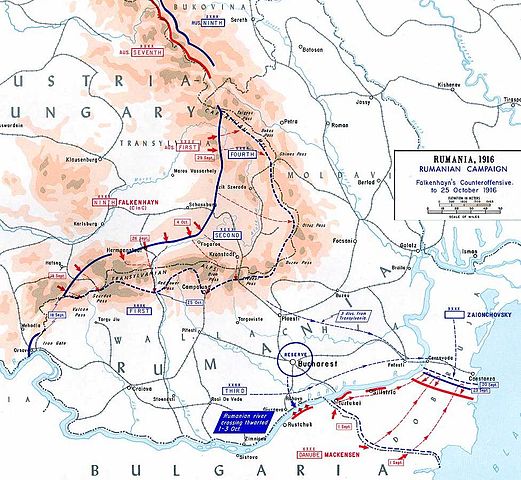
This map shows the Central Powers first counter-attacks against Romania in September-October of 1916.
This map was created by the Department of Military Art and Engineering, at the U.S. Military Academy (West Point). The initial version was created under the supervision of General Vincent Esposito in 1959. It is now available on the West Point web site at: http://www.dean.usma.edu/history/web03/atlases/great%20war/great%20war%20%20pages/great%20war%20map%2037.htm
The map image has been cropped to remove unneeded territory.
Llicència
Aquesta obra és en el domini públic als Estats Units perquè és una obra del govern federal dels Estats Units sota els termes del Títol 17, Capítol 1, Secció 105 del Codi dels EUA. Vegeu drets d'autor.
Nota: Això només s'aplica a obres del Govern Federal i no a les dels estats individuals ni cap altra subdivisió administrativa. Aquesta plantilla tampoc no s'aplica a dissenys de segells de correus publicats pel Servei Postal dels Estats Units des de 1978 (vegeu 206.02(b) of Compendium II: Copyright Office Practices).
|
 | |
| Aquest fitxer està identificat com a lliure de restriccions conegudes sota la llei de drets d'autor, inclosos els drets veïns. | ||
derivative works
Derivative works of this file: CampañaRumanaSeptiembreOctubre1916.svg
Historial del fitxer
Cliqueu una data/hora per veure el fitxer tal com era aleshores.
| Data/hora | Miniatura | Dimensions | Usuari/a | Comentari | |
|---|---|---|---|---|---|
| actual | 18:44, 28 des 2006 | | 974 × 898 (159 Ko) | Electionworld | {{ew|en|Cglassey}} == Summary == This map shows the Centeral Powers first counter-attacks against Romania in September-October of 1916. This map was created by the Department of Military Art and Engineering, at the U.S. Military Academy (West Point). The |
Ús del fitxer
La pàgina següent utilitza aquest fitxer:
Ús global del fitxer
Utilització d'aquest fitxer en altres wikis:
- Utilització a ar.wikipedia.org
- Utilització a azb.wikipedia.org
- Utilització a ba.wikipedia.org
- Utilització a be-tarask.wikipedia.org
- Utilització a be.wikipedia.org
- Utilització a bg.wikipedia.org
- Utilització a cs.wikipedia.org
- Utilització a de.wikipedia.org
- Utilització a el.wikipedia.org
- Utilització a en.wikipedia.org
- Utilització a es.wikipedia.org
- Utilització a fr.wikipedia.org
- Utilització a he.wikipedia.org
- Utilització a hu.wikipedia.org
- Utilització a it.wikipedia.org
- Utilització a ja.wikipedia.org
- Utilització a nl.wikipedia.org
- Utilització a pl.wikipedia.org
- Utilització a pt.wikipedia.org
- Utilització a ro.wikipedia.org
- Participarea României la Primul Război Mondial
- Erich von Falkenhayn
- Ofensiva Armatei României în Transilvania în 1916
- Participarea României în campania anului 1916
- Bătălia de la Sibiu (1916)
- Operația de apărare a trecătorilor Carpaților (1916)
- Bătălia de la Brașov (1916)
- Bătălia de pe Valea Oltului (1916)
- Bătălia de pe Valea Prahovei (1916)
- Bătălia din zona Bran-Câmpulung (1916)
- Prima bătălie de pe Valea Jiului (1916)
- Prima bătălie de la Oituz (1916)
- A doua bătălie de la Oituz (1916)
- Operația de apărare de pe frontul de sud (1916)
Vegeu més usos globals d'aquest fitxer.