Fitxer:Sandzak region map.png
Aparença

Mida d'aquesta previsualització: 628 × 600 píxels. Altres resolucions: 251 × 240 píxels | 503 × 480 píxels | 974 × 930 píxels.
Fitxer original (974 × 930 píxels, mida del fitxer: 53 Ko, tipus MIME: image/png)
Historial del fitxer
Cliqueu una data/hora per veure el fitxer tal com era aleshores.
| Data/hora | Miniatura | Dimensions | Usuari/a | Comentari | |
|---|---|---|---|---|---|
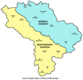
| actual | 10:14, 3 oct 2009 |  | 974 × 930 (53 Ko) | WikiEditor2004 | {{Information |Description={{en|1=Map of Sandžak region in Serbia and Montenegro. Note: This map show Sandžak region in its largest geographical extent. According to some other views, Montenegrin municipalities of Plav and Andrijevica might not belong t |
Ús del fitxer
La pàgina següent utilitza aquest fitxer:
Ús global del fitxer
Utilització d'aquest fitxer en altres wikis:
- Utilització a ar.wikipedia.org
- Utilització a bs.wikipedia.org
- Utilització a de.wikipedia.org
- Utilització a en.wikipedia.org
- Utilització a es.wikipedia.org
- Utilització a fr.wikipedia.org
- Utilització a hr.wikipedia.org
- Utilització a hu.wikipedia.org
- Utilització a id.wikipedia.org
- Utilització a it.wikipedia.org
- Utilització a ja.wikipedia.org
- Utilització a ko.wikipedia.org
- Utilització a mk.wikipedia.org
- Utilització a mn.wikipedia.org
- Utilització a nl.wikipedia.org
- Utilització a no.wikipedia.org
- Utilització a pl.wikipedia.org
- Utilització a pt.wikipedia.org
- Utilització a ro.wikipedia.org
- Utilització a sh.wikipedia.org
- Utilització a sk.wikipedia.org
- Utilització a sq.wikipedia.org
- Utilització a tr.wikipedia.org
- Utilització a uk.wikipedia.org
- Utilització a zh.wikipedia.org
- Utilització a zh.wikivoyage.org

