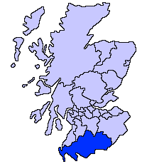
Fitxer:ScotlandDumfriesGalloway.png
Aparença
ScotlandDumfriesGalloway.png (200 × 230 píxels, mida del fitxer: 4 Ko, tipus MIME: image/png)
Historial del fitxer
Cliqueu una data/hora per veure el fitxer tal com era aleshores.
| Data/hora | Miniatura | Dimensions | Usuari/a | Comentari | |
|---|---|---|---|---|---|
| actual | 22:31, 17 maig 2005 |  | 200 × 230 (4 Ko) | Voyager | Dumfries and Galloway unitary council Slightly edited version of a map drawn by Morwen {{GFDL}} Category:Maps of Scottish unitary councils |
Ús del fitxer
La pàgina següent utilitza aquest fitxer:
Ús global del fitxer
Utilització d'aquest fitxer en altres wikis:
- Utilització a ast.wikipedia.org
- Utilització a be.wikipedia.org
- Utilització a bg.wikipedia.org
- Utilització a cy.wikipedia.org
- Utilització a de.wikipedia.org
- Utilització a de.wikivoyage.org
- Utilització a en.wikipedia.org
- Utilització a eu.wikipedia.org
- Dumfries eta Galloway
- Dumfries
- Lankide:Euskaldunaa
- Stranraer
- Annan
- Txantiloi:Dumfries eta Galloway
- Wikiproiektu:Irlanda, Gales eta Eskoziako udalerriak
- Applegarthtown
- Inch (Dumfries eta Galloway)
- Bladnoch (Wigtownshire)
- Cairnryan
- Glasserton
- Glenluce
- Kirkcolm
- Kirkmaiden
- Leswalt
- Mochrum
- New Luce
- Newton Stewart
- Old Luce
- Penninghame
- Port William (Dumfries eta Galloway)
- Portpatrick
- Sandhead
- Sorbie
- Stoneykirk
- Wigtown
- Whithorn
- Kirkcowan
- Kirkinner
- Anwoth
- Caerlaverock
- Barburgh Mill
- Brow (Dumfries eta Galloway)
- Dalgarnock
Vegeu més usos globals d'aquest fitxer.


