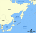
Fitxer:Sea of Okhotsk map with state labels.png
Aparença

Mida d'aquesta previsualització: 657 × 599 píxels. Altres resolucions: 263 × 240 píxels | 526 × 480 píxels | 990 × 903 píxels.
Fitxer original (990 × 903 píxels, mida del fitxer: 84 Ko, tipus MIME: image/png)
Historial del fitxer
Cliqueu una data/hora per veure el fitxer tal com era aleshores.
| Data/hora | Miniatura | Dimensions | Usuari/a | Comentari | |
|---|---|---|---|---|---|
| actual | 18:13, 23 abr 2010 |  | 990 × 903 (84 Ko) | Ras67 | cropped |
| 11:58, 4 ago 2007 |  | 1.000 × 913 (85 Ko) | Nihad Hamzic | Greatly reduced file size by removing the alpha channel, what enabled me to losslessly reduce the color domain do 8-bit. If alpha channel is indeed needed, then revert this image. | |
| 16:40, 24 oct 2005 |  | 1.000 × 913 (408 Ko) | NormanEinstein | This is a map showing the location of the Sea of Okhotsk. The sea is bordered by Russia and Japan. Created by NormanEinstein, October 24, 2005. {{GFDL-self}} Category:Maps of seas |
Ús del fitxer
La pàgina següent utilitza aquest fitxer:
Ús global del fitxer
Utilització d'aquest fitxer en altres wikis:
- Utilització a ace.wikipedia.org
- Utilització a af.wikipedia.org
- Utilització a als.wikipedia.org
- Utilització a ar.wikipedia.org
- Utilització a ast.wikipedia.org
- Utilització a avk.wikipedia.org
- Utilització a azb.wikipedia.org
- Utilització a az.wikipedia.org
- Utilització a az.wiktionary.org
- Utilització a bat-smg.wikipedia.org
- Utilització a be-tarask.wikipedia.org
- Utilització a be.wikipedia.org
- Utilització a bg.wikipedia.org
- Utilització a bn.wikipedia.org
- Utilització a br.wikipedia.org
- Utilització a bxr.wikipedia.org
- Utilització a ca.wikinews.org
- Utilització a ckb.wikipedia.org
- Utilització a cs.wikipedia.org
- Utilització a cy.wikipedia.org
- Utilització a da.wikipedia.org
- Utilització a de.wikipedia.org
- Utilització a dsb.wikipedia.org
- Utilització a el.wikipedia.org
- Utilització a en.wikipedia.org
Vegeu més usos globals d'aquest fitxer.


