
Fitxer:Six Day War Territories.png
Six_Day_War_Territories.png (398 × 599 píxels, mida del fitxer: 53 Ko, tipus MIME: image/png)
| Aquest fitxer i la informació mostrada a continuació provenen del dipòsit multimèdia lliure Wikimedia Commons. |
Resum

|
File:Six Day War Terrritories.svg és una versió vectorial (SVG) d'aquest fitxer. En cas de ser millor, hauria de ser emprada en lloc d'aquesta imatge tramada.
File:Six Day War Territories.png → File:Six Day War Terrritories.svg
Per a més informació pel que fa als gràfics vectorials, llegiu la transició a SVG en Commons. També hi ha informació quant a la compatibilitat del MediaWiki amb les imatges SVG. |
 |
| Descripció |
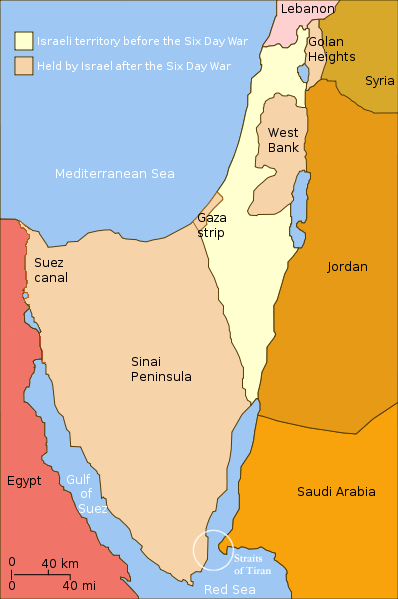
English: Changes in political boundaries following the Six Day war. In yellow: Israel within the "Green Line" borders (per 1949 ceasefire agreements); In light maroon: Territories Israel seized during the war and maintained its control over them in the aftermath of the war. The Straits of Tiran are circled, between the Gulf of Aqaba/Eilat, and the Red Sea. |
| Data | Data desconeguda |
| Font | Yom Kippur War map.svg |
| Autor | User:Ling.Nut |
| Altres versions |
[]
|


.png)


"Self-made line drawing of a map of Israel's territories before and after the Six Day War. Author: User:Ling.Nut Source of line drawing: File:Yom Kippur War map.svg authored by User:Raul654, sourced to now-deleted image Image:Jom kippur war.jpg, which was originally uploaded to the polish Wikipedia at http://pl.wikipedia.org/wiki/Grafika:Jom_kippur_war.jpg -- Ministerstwo Spraw Zagranicznych Izraela, za zgodÄ… Ambasady Izraela w Polsce. -- Ministry of Foreign Affairs of Israel, with the permission of Israel Embassy in Poland"
Llicència
- Sou lliure de:
- compartir – copiar, distribuir i comunicar públicament l'obra
- adaptar – fer-ne obres derivades
- Amb les condicions següents:
- reconeixement – Heu de donar la informació adequada sobre l'autor, proporcionar un enllaç a la llicència i indicar si s'han realitzat canvis. Podeu fer-ho amb qualsevol mitjà raonable, però de cap manera no suggereixi que l'autor us dóna suport o aprova l'ús que en feu.
- compartir igual – Si modifiqueu, transformeu, o generareu amb el material, haureu de distribuir les vostres contribucions sota una llicència similar o una de compatible com l'original
Historial del fitxer
Cliqueu una data/hora per veure el fitxer tal com era aleshores.
| Data/hora | Miniatura | Dimensions | Usuari/a | Comentari | |
|---|---|---|---|---|---|
| actual | 23:32, 11 nov 2010 | | 398 × 599 (53 Ko) | 99of9 | Reverted to version as of 07:04, 25 July 2010. Both POV versions should be at different locations, marked with POV and linked. |
| 13:06, 8 nov 2010 |  | 398 × 599 (52 Ko) | Supreme Deliciousness | Israeli territory before the Six day war is the same as after the Six day war. | |
| 09:04, 25 jul 2010 |  | 398 × 599 (53 Ko) | Ling.Nut | {{Information |Description={{en|1=Israeli territories before and after the Six Day War. The Straits of Tiran are circled, between the Gulf of Aqaba, and the Red Sea.}} |Source=Yom Kippur War map.svg |Author=User:Ling.Nut |Date= |Permission= |other_ver |
Ús del fitxer
La pàgina següent utilitza aquest fitxer:
Ús global del fitxer
Utilització d'aquest fitxer en altres wikis:
- Utilització a he.wikipedia.org
- Utilització a nl.wikipedia.org
- Utilització a ug.wikipedia.org
- Utilització a www.wikidata.org