
Fitxer:SmallAsteroidImpacts-Frequency-Bolide-20141114.jpg
Fitxer original (1.519 × 1.064 píxels, mida del fitxer: 608 Ko, tipus MIME: image/jpeg)
| Aquest fitxer i la informació mostrada a continuació provenen del dipòsit multimèdia lliure Wikimedia Commons. |
Resum
| Descripció |
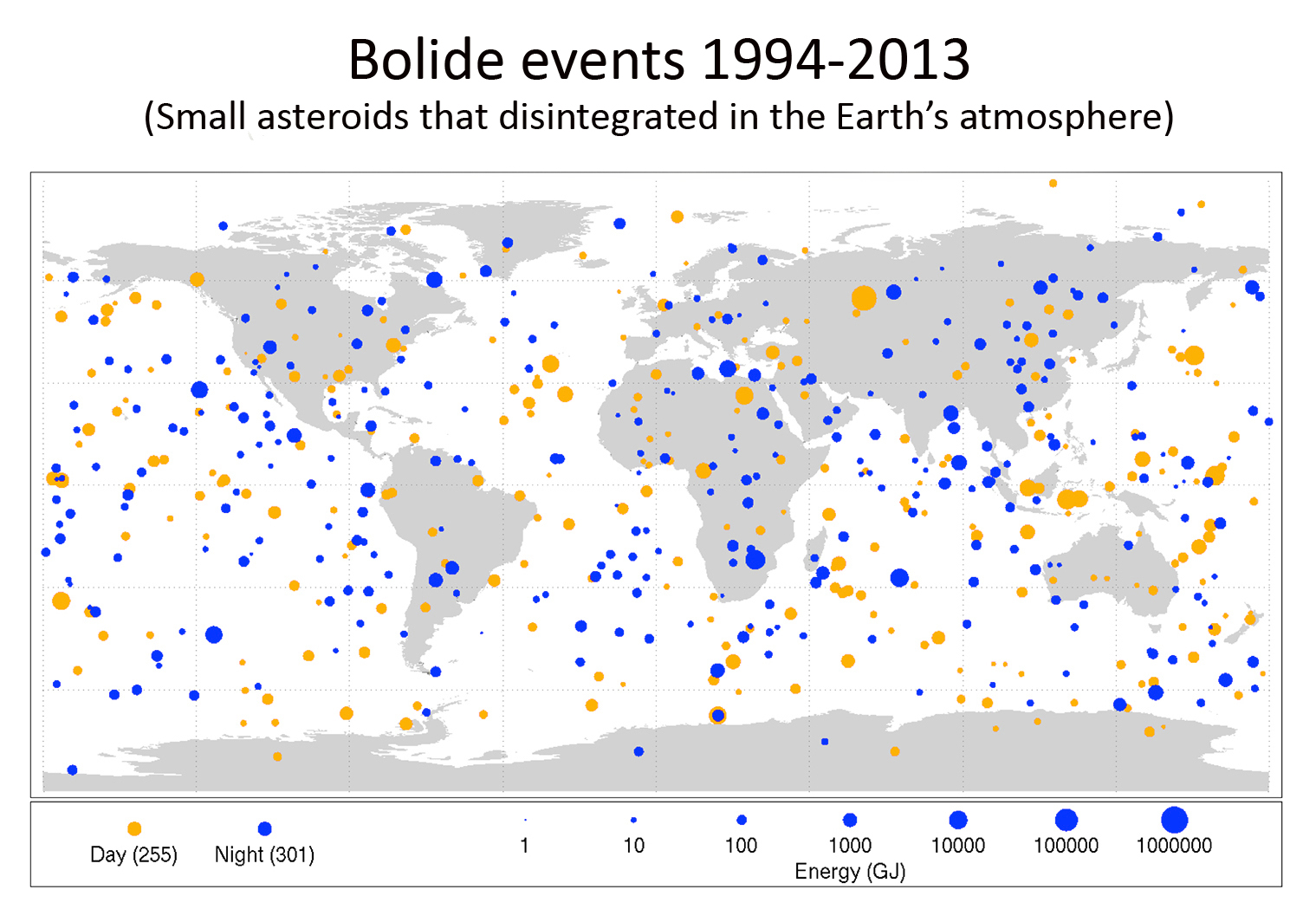
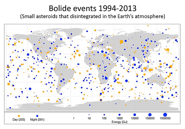
English: New Map Shows Frequency of Small Asteroid Impacts, Provides Clues on Larger Asteroid Population
This diagram maps the data gathered from 1994-2013 on small asteroids impacting Earth's atmosphere IMAGE: DESCRIPTION: Finding and characterizing hazardous asteroids to protect our home planet is a high priority for NASA. It is one of the reasons NASA has increased by a factor of 10 investments in asteroid detection, characterization and mitigation activities over the last five years. In addition, NASA has aggressively developed strategies and plans with its partners in the U.S. and abroad to detect, track and characterize NEOs. These activities also will help identify NEOs that might pose a risk of Earth impact, and further help inform developing options for planetary defense. The public can help participate in the hunt for potentially hazardous Near Earth Objects through the Asteroid Grand Challenge, which aims to create a plan to find all asteroid threats to human populations and know what to do about them. NASA is also pursuing an Asteroid Redirect Mission (ARM) which will identify, redirect and send astronauts to explore an asteroid. Among its many exploration goals, the mission could demonstrate basic planetary defense techniques for asteroid deflection. |
| Data | |
| Font | http://www.jpl.nasa.gov/news/news.php?release=2014-397 (image link) |
| Autor | NASA/Planetary Science |

|
Aquesta imatge (de tipus mapa) s'hauria de tornar a crear utilitzant gràfics vectorials com ara un fitxer SVG. Això té diversos avantatges; en trobareu més informació a Commons:Media for cleanup. Si ja disposeu d'una versió d'aquesta imatge en format SVG, us preguem que la pengeu; després, reemplaceu aquesta plantilla amb la plantilla {{Vector version available|nom nou de la imatge.svg}} en aquesta imatge.
|


Llicència
| Aquest fitxer és en el domini públic perquè ha estat creat per la NASA. L'avís legal de la NASA diu que «el material de la NASA no està protegit per copyright si no es diu el contrari». (NASA copyright policy page o JPL Image Use Policy). | ||
 |
Atenció:
|
Historial del fitxer
Cliqueu una data/hora per veure el fitxer tal com era aleshores.
| Data/hora | Miniatura | Dimensions | Usuari/a | Comentari | |
|---|---|---|---|---|---|
| actual | 03:17, 8 des 2018 | | 1.519 × 1.064 (608 Ko) | Hohum | Cleanup title area |
| 20:45, 28 feb 2016 |  | 1.519 × 1.064 (592 Ko) | John | MOSCAP | |
| 21:19, 14 nov 2014 |  | 1.519 × 1.064 (549 Ko) | Drbogdan | User created page with UploadWizard |
Ús del fitxer
La pàgina següent utilitza aquest fitxer:
Ús global del fitxer
Utilització d'aquest fitxer en altres wikis:
- Utilització a ar.wikipedia.org
- Utilització a bn.wikipedia.org
- Utilització a cs.wikipedia.org
- Utilització a de.wikipedia.org
- Utilització a en.wikipedia.org
- Utilització a en.wikiversity.org
- Utilització a es.wikipedia.org
- Utilització a et.wikipedia.org
- Utilització a fr.wikipedia.org
- Utilització a he.wikipedia.org
- Utilització a mk.wikipedia.org
- Utilització a pl.wikipedia.org
- Utilització a pt.wikipedia.org
- Utilització a simple.wikipedia.org
- Utilització a si.wikipedia.org
- Utilització a sk.wikipedia.org
- Utilització a tr.wikipedia.org
- Utilització a zh.wikipedia.org