
Fitxer:The Walkington Hayride - geograph.org.uk - 470593.jpg
No hi ha cap versió amb una resolució més gran.
The_Walkington_Hayride_-_geograph.org.uk_-_470593.jpg (640 × 472 píxels, mida del fitxer: 101 Ko, tipus MIME: image/jpeg)
| Aquest fitxer i la informació mostrada a continuació provenen del dipòsit multimèdia lliure Wikimedia Commons. |
This is a photo of listed building number 1162565. |
Resum
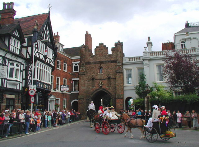
| Descripció |
English: The Walkington Hayride, Beverley, East Riding of Yorkshire, England. Participants in the Walkington Hayride pass through the North Bar gate on their way into Beverley town centre. The charity event was founded by Ernie Teal in 1967 but this is expected to be the last procession due to dwindling numbers of heavy horses and horsemen. North Bar (the brick arch in the centre of the picture) is the only one remaining of a number of gates which once guarded the entrances to Beverley. It was built by the town council in 1409 and cost a fraction over £96. |
| Data | |
| Font | From geograph.org.uk |
| Autor | Paul Glazzard |
| Permís (Com reutilitzar aquest fitxer) |
Creative Commons Attribution Share-alike license 2.0 |
| Reconeixement (required by the license) | Paul Glazzard / The Walkington Hayride / |
| Posició de la càmera | | Aquesta i altres imatges properes a: OpenStreetMap |
|---|
_heading:112.00&language=ca)
| Posició de l'objecte | | Aquesta i altres imatges properes a: OpenStreetMap |
|---|
_heading:112.00&language=ca)
Llicència

|
Aquesta imatge prové de la col·lecció del projecte Geograph British Isles. Vegeu la pàgina d'aquesta fotografia al lloc web Geograph per a més informació del fotògraf. El titular dels drets d'autor d'aquesta imatge és Paul Glazzard i autoritza utilitzar-la sota la llicència Reconeixement-CompartirIgual 2.0 de Creative Commons.
|
Aquest fitxer està publicat sota la llicència de Creative Commons Reconeixement i Compartir Igual 2.0 Genèrica.
Reconeixement: Paul Glazzard
- Sou lliure de:
- compartir – copiar, distribuir i comunicar públicament l'obra
- adaptar – fer-ne obres derivades
- Amb les condicions següents:
- reconeixement – Heu de donar la informació adequada sobre l'autor, proporcionar un enllaç a la llicència i indicar si s'han realitzat canvis. Podeu fer-ho amb qualsevol mitjà raonable, però de cap manera no suggereixi que l'autor us dóna suport o aprova l'ús que en feu.
- compartir igual – Si modifiqueu, transformeu, o generareu amb el material, haureu de distribuir les vostres contribucions sota una llicència similar o una de compatible com l'original
Historial del fitxer
Cliqueu una data/hora per veure el fitxer tal com era aleshores.
| Data/hora | Miniatura | Dimensions | Usuari/a | Comentari | |
|---|---|---|---|---|---|
| actual | 19:07, 22 abr 2013 | | 640 × 472 (101 Ko) | Gnesener1900 | contrast |
| 01:40, 5 feb 2011 |  | 640 × 472 (97 Ko) | GeographBot | == {{int:filedesc}} == {{Information |description={{en|1=The Walkington Hayride Participants in the Walkington Hayride pass through the North Bar gate on their way into Beverley town centre. The charity event was founded by Ernie Teal in 1967 but this is |
Ús del fitxer
La pàgina següent utilitza aquest fitxer:
Ús global del fitxer
Utilització d'aquest fitxer en altres wikis:
- Utilització a en.wikipedia.org
- Utilització a eu.wikipedia.org