
Fitxer:Theoreticaltownshipmap.gif
Mida d'aquesta previsualització: 554 × 600 píxels. Altres resolucions: 222 × 240 píxels | 444 × 480 píxels | 694 × 751 píxels.
Fitxer original (694 × 751 píxels, mida del fitxer: 70 Ko, tipus MIME: image/gif)
| Aquest fitxer i la informació mostrada a continuació provenen del dipòsit multimèdia lliure Wikimedia Commons. |
Resum
| Descripció |
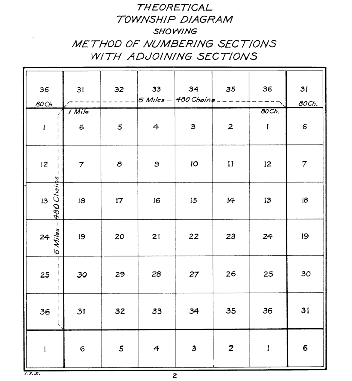
English: The image depicts a standard survey township with its 36 sections and the correponding sections from the surrounding survey townships. |
|||
| Data | ||||
| Font | The image was tansferred from the en.wiki. If necessary, it could be found here. | |||
| Autor |
The image was done by the US Interior Bureau of Land Management
|
Llicència
Aquesta obra és en el domini públic als Estats Units perquè és una obra del govern federal dels Estats Units sota els termes del Títol 17, Capítol 1, Secció 105 del Codi dels EUA. Vegeu drets d'autor.
Nota: Això només s'aplica a obres del Govern Federal i no a les dels estats individuals ni cap altra subdivisió administrativa. Aquesta plantilla tampoc no s'aplica a dissenys de segells de correus publicats pel Servei Postal dels Estats Units des de 1978 (vegeu 206.02(b) of Compendium II: Copyright Office Practices).
|
 | |
| Aquest fitxer està identificat com a lliure de restriccions conegudes sota la llei de drets d'autor, inclosos els drets veïns. | ||
| This image is a work of a Bureau of Land Management* employee, taken or made as part of that person's official duties. As a work of the U.S. federal government, the image is in the public domain in the United States. *or predecessor organization |
Historial del fitxer
Cliqueu una data/hora per veure el fitxer tal com era aleshores.
| Data/hora | Miniatura | Dimensions | Usuari/a | Comentari | |
|---|---|---|---|---|---|
| actual | 23:25, 22 des 2011 | | 694 × 751 (70 Ko) | Wars |
Ús del fitxer
La pàgina següent utilitza aquest fitxer:
Ús global del fitxer
Utilització d'aquest fitxer en altres wikis:
- Utilització a en.wikipedia.org
- Utilització a fr.wikipedia.org
- Utilització a hu.wikipedia.org
- Utilització a it.wikipedia.org
- Utilització a ro.wikipedia.org