
Fitxer:Utah Territory evolution animation - August 2011.gif
Mida d'aquesta previsualització: 763 × 600 píxels. Altres resolucions: 305 × 240 píxels | 611 × 480 píxels | 1.000 × 786 píxels.
Fitxer original (1.000 × 786 píxels, mida del fitxer: 158 Ko, tipus MIME: image/gif, en bucle, 6 fotogrames, 15 s)
| Aquest fitxer i la informació mostrada a continuació provenen del dipòsit multimèdia lliure Wikimedia Commons. |
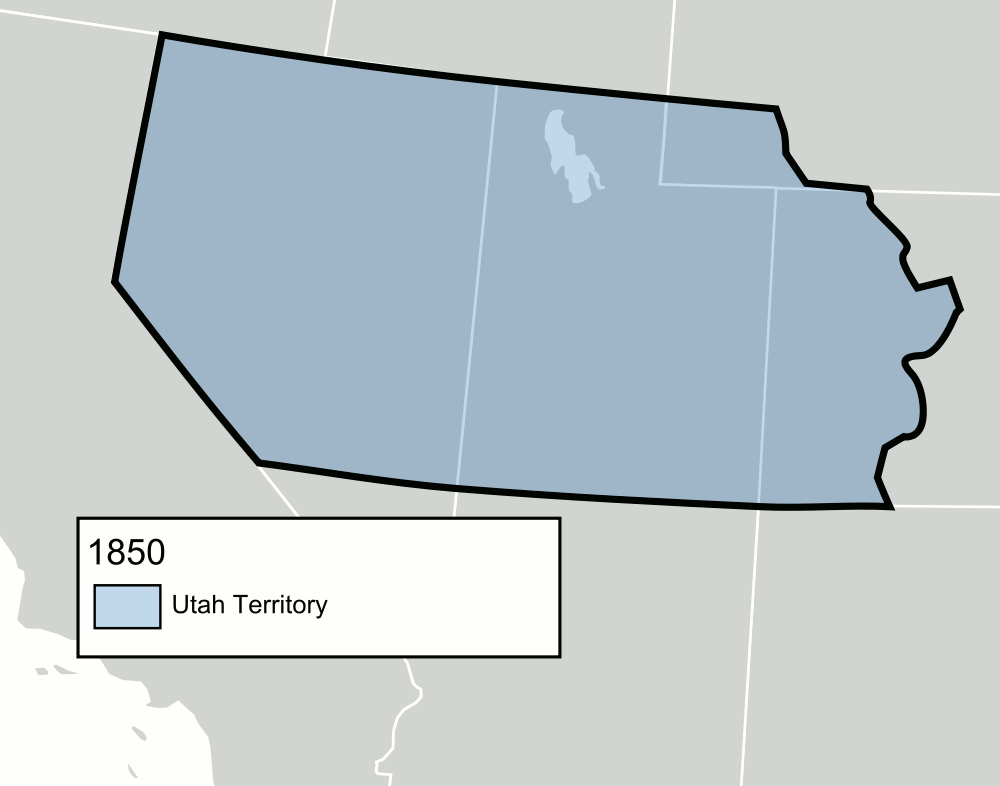
| Descripció | An animated GIF of the Utah Territory as it evolved from 1850 to 1896, when statehood was granted. The territory's boundaries may not be exact. |
| Data | (UTC) |
| Font | |
| Autor |
|
_-_Geographicus_-_UtahNewMexico-colton-1855.jpg)
Jo, el titular dels drets d'autor d'aquest treball, el public sota les següents llicències:
| Aquest fitxer està subjecte a la llicència de Creative Commons Reconeixement i Compartir Igual 3.0 No adaptada. | ||
| ||
| Aquest avís de llicència s'ha afegit a aquest fitxer d'acord amb l'actualització de la llicència GFDL. |

|
S'autoritza la còpia, la distribució i la modificació d'aquest document sota els termes de la llicència de documentació lliure GNU versió 1.2 o qualsevol altra versió posterior que publiqui la Free Software Foundation; sense seccions invariants, ni textos de portada, ni textos de contraportada. S'inclou una còpia d'aquesta llicència en la secció titulada GNU Free Documentation License. |
Podeu seleccionar la llicència que vulgueu.
Registre original de càrregues
This image is a derivative work of the following images:
- File:Blank_US_Map.svg licensed with Cc-by-sa-3.0-migrated, GFDL
- 2009-11-05T19:44:02Z NuclearVacuum 959x593 (91518 Bytes) minor fix from previous upload
- 2009-11-05T19:39:42Z NuclearVacuum 959x593 (88399 Bytes) Fixed up the borders so they are connected with each state and loosing that gap between them.
- 2008-10-09T16:36:40Z Howcheng 959x593 (80121 Bytes) Reverted to version as of 08:32, 14 June 2007
- 2008-03-12T00:20:02Z AMK1211 959x593 (174744 Bytes) Added borders: Light blue for water borders and black for land borders (international borders thicker).
- 2007-06-14T08:32:47Z Fibonacci 959x593 (80121 Bytes) Optimised code.
- 2006-07-12T23:00:30Z Theshibboleth 959x593 (90537 Bytes) The line framework around Alaska and Hawaii has been pushed a bit
- 2006-07-12T06:35:19Z Theshibboleth 959x593 (89828 Bytes) added DC
- 2006-07-12T06:05:05Z Theshibboleth 959x593 (89649 Bytes) {{Information |Description=A blank map of the United States in scalable vector form. |Source=Own work, based on [[:Image:Electorial map.svg]], inspired by [[:Image:BlankMap-World.png]] |Date=11 July 2006 |Author=[[User:Theshi
Historial del fitxer
Cliqueu una data/hora per veure el fitxer tal com era aleshores.
| Data/hora | Miniatura | Dimensions | Usuari/a | Comentari | |
|---|---|---|---|---|---|
| actual | 20:12, 8 juny 2013 | | 1.000 × 786 (158 Ko) | Mangoman88 | Fixed the name of the Nebraska Territory on the 1861 slide |
| 03:16, 18 jul 2012 |  | 1.000 × 786 (158 Ko) | Mangoman88 | Fix border along the 37th parallel north | |
| 07:06, 15 ago 2011 |  | 500 × 393 (70 Ko) | Mangoman88 | Fixing gif transparency | |
| 06:33, 15 ago 2011 |  | 500 × 393 (71 Ko) | Mangoman88 | {{Information |Description=An animated {{w|Graphics Interchange Format|GIF}} of the {{w|Utah Territory}} as it evolved from 1850 to 1896, when statehood was granted. The territory's boundaries may not be exact. |Source=*[[:File:Blank_US_Map.svg|Blank_US_M |
Ús del fitxer
La pàgina següent utilitza aquest fitxer:
Ús global del fitxer
Utilització d'aquest fitxer en altres wikis:
- Utilització a de.wikipedia.org
- Utilització a en.wikipedia.org
- Utilització a es.wikipedia.org
- Utilització a fa.wikipedia.org
- Utilització a he.wikipedia.org
- Utilització a it.wikipedia.org
- Utilització a nl.wikipedia.org
- Utilització a no.wikipedia.org
- Utilització a pt.wikipedia.org
- Utilització a sv.wikipedia.org
- Utilització a vi.wikipedia.org