
Fitxer:WW2 Holocaust Europe map-es.svg

Mida d'aquesta previsualització PNG del fitxer SVG: 721 × 600 píxels. Altres resolucions: 289 × 240 píxels | 577 × 480 píxels | 923 × 768 píxels | 1.231 × 1.024 píxels | 2.461 × 2.048 píxels | 1.310 × 1.090 píxels.
Fitxer original (fitxer SVG, nominalment 1.310 × 1.090 píxels, mida del fitxer: 593 Ko)
| Aquest fitxer i la informació mostrada a continuació provenen del dipòsit multimèdia lliure Wikimedia Commons. |
Resum
| Descripció |
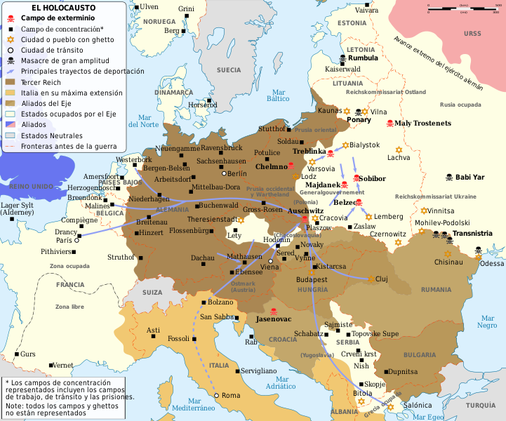
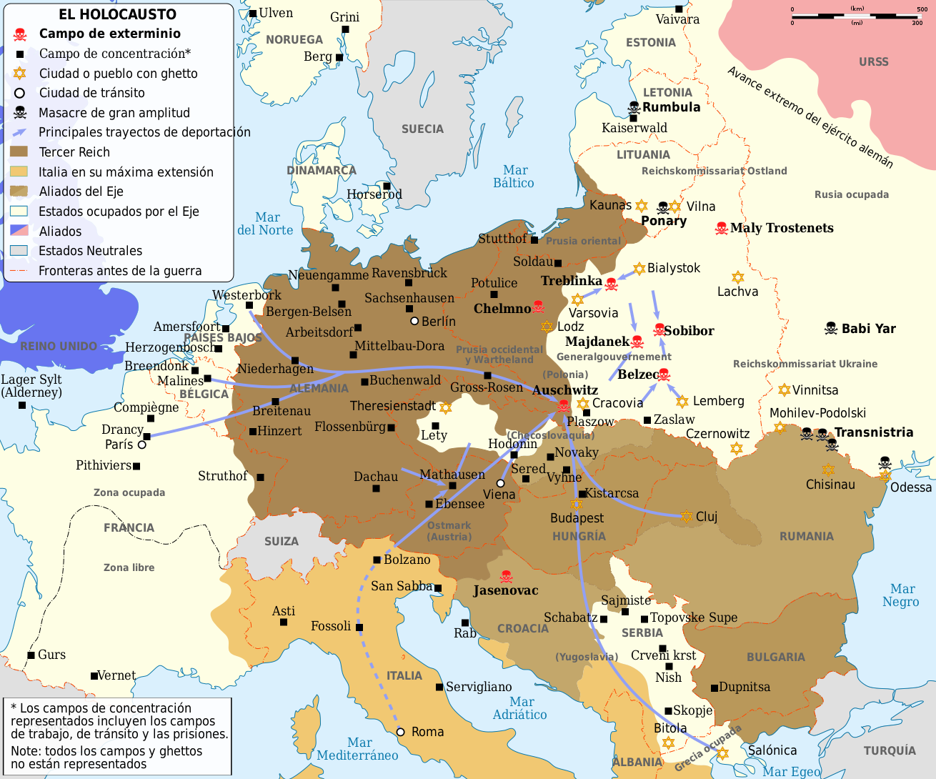
English: Map of the Holocaust in Europe during World War II, 1939-1945.
This map shows all extermination camps (or death camps), most major concentration camps, labor camps, prison camps, ghettos, major deportation routes and major massacre sites. Notes: 1. Extermination camps WERE dedicated death camps, but all camps and ghettos took a toll of many, many lives. 2. Concentration camps include labor camps, prison camps & transit camps. 3. Not all camps & ghettos are shown. 4. Borders are at the height of Axis domination (1942). 5. Some regions have German designations (e.g. "Ostland"), with the present country name denoted in uppercase letters in parenthesis below the German designation (e.g. "(AUSTRIA)"). 6. Present (2007) borders are dotted. Español: Mapa del Holocausto en Europa, 1939-1945. Muestra todos los centros de exterminio, la mayoría de campos de concentración, de trabajo, prisiones, ghettos, principales rutas de deportación y principales lugares de masacres |
| Data | |
| Font | file:WW2_Holocaust_Europe_map-fr.svg: Sémhur |
| Autor | |
| Altres versions |
[]
|


.png)


.png)


Traducción de imagen en francés
Llicència
Jo, el titular dels drets d'autor d'aquest treball, el public sota les següents llicències:

|
S'autoritza la còpia, la distribució i la modificació d'aquest document sota els termes de la llicència de documentació lliure GNU versió 1.2 o qualsevol altra versió posterior que publiqui la Free Software Foundation; sense seccions invariants, ni textos de portada, ni textos de contraportada. S'inclou una còpia d'aquesta llicència en la secció titulada GNU Free Documentation License. |
Aquest fitxer està subjecte a la llicència de Creative Commons Reconeixement 3.0 No adaptada.
- Sou lliure de:
- compartir – copiar, distribuir i comunicar públicament l'obra
- adaptar – fer-ne obres derivades
- Amb les condicions següents:
- reconeixement – Heu de donar la informació adequada sobre l'autor, proporcionar un enllaç a la llicència i indicar si s'han realitzat canvis. Podeu fer-ho amb qualsevol mitjà raonable, però de cap manera no suggereixi que l'autor us dóna suport o aprova l'ús que en feu.
Podeu seleccionar la llicència que vulgueu.
Historial del fitxer
Cliqueu una data/hora per veure el fitxer tal com era aleshores.
| Data/hora | Miniatura | Dimensions | Usuari/a | Comentari | |
|---|---|---|---|---|---|
| actual | 21:55, 2 juny 2021 | | 1.310 × 1.090 (593 Ko) | Tholme | Remove nested tspan |
| 04:49, 8 juny 2009 |  | 1.310 × 1.090 (593 Ko) | Andreasmperu | {{Information |Description={{en|1=Map of the Holocaust in Europe during World War II, 1939-1945. <br> This map shows all extermination camps (or ''death camps''), most major concentration camps, labor camps, prison camps, ghettos, major deportation routes |
Ús del fitxer
Les 2 pàgines següents utilitzen aquest fitxer:
Ús global del fitxer
Utilització d'aquest fitxer en altres wikis:
- Utilització a ast.wikipedia.org
- Utilització a es.wikipedia.org
- Utilització a eu.wikipedia.org
- Utilització a gl.wikipedia.org
- Utilització a pt.wikipedia.org
- Utilització a pt.wikinews.org
- Utilització a ro.wikipedia.org