
Fitxer:Wettzell Laser Ranging System.jpg

Mida d'aquesta previsualització: 800 × 533 píxels. Altres resolucions: 320 × 213 píxels | 640 × 426 píxels | 1.024 × 682 píxels.
Fitxer original (1.024 × 682 píxels, mida del fitxer: 165 Ko, tipus MIME: image/jpeg)
| Aquest fitxer i la informació mostrada a continuació provenen del dipòsit multimèdia lliure Wikimedia Commons. |
Resum
| Descripció |
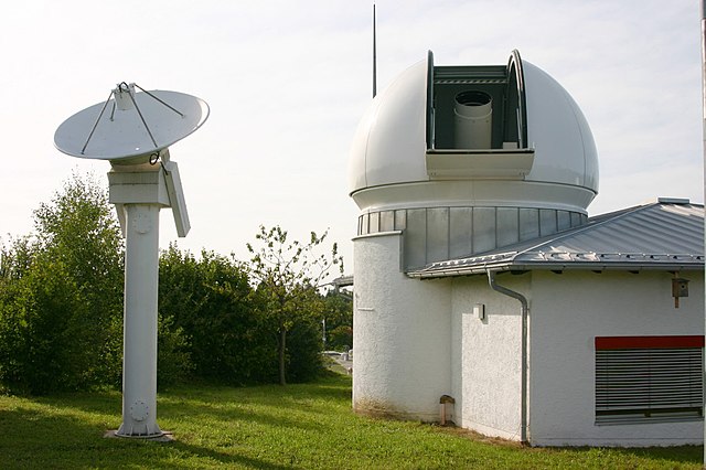
English: Wettzell Laser Ranging System (WLRS), the satellite and lunar laser ranging system of the geodetic observatory in Wettzell, Bavaria. The 75cm telescope in the dome is both used to send the laser pulses and to observe the reflected signal. The small radar dish besides the dome is used to monitor air traffic: The laser is automatically switched off when a aircraft approaches the target position of the laser.
Deutsch: Wettzell Laser Ranging System (WLRS), ein System zur Messung der Entfernung von künstlichen Erdsatelliten und des Mondes am geodätischen Observatorium Wettzell, Bayern. Das 75cm Teleskop in der Kuppel wird sowohl zum Aussenden der Laserimpulse, als auch zum Empfangen des reflektierten Signals verwendet. Die kleine Radarschüssel neben der Kuppel dient der Überwachung des Flugverkehrs: Der Laser wird automatisch abgeschaltet, wenn sich ein Flugzeug der Zielposition des Lasers nähert. |
| Data | |
| Font | Treball propi |
| Autor | H. Raab (User:Vesta) |
| Altres versions | See also Image:Geodetic Observatory Wettzell.jpg |
| Posició de la càmera | | Aquesta i altres imatges properes a: OpenStreetMap |
|---|
Llicència
Jo, el titular dels drets d'autor d'aquest treball, el public sota les següents llicències:

|
S'autoritza la còpia, la distribució i la modificació d'aquest document sota els termes de la llicència de documentació lliure GNU versió 1.2 o qualsevol altra versió posterior que publiqui la Free Software Foundation; sense seccions invariants, ni textos de portada, ni textos de contraportada. S'inclou una còpia d'aquesta llicència en la secció titulada GNU Free Documentation License. |
Aquest fitxer està subjecte a la llicència de Creative Commons Reconeixement i Compartir Igual 3.0 No adaptada.
- Sou lliure de:
- compartir – copiar, distribuir i comunicar públicament l'obra
- adaptar – fer-ne obres derivades
- Amb les condicions següents:
- reconeixement – Heu de donar la informació adequada sobre l'autor, proporcionar un enllaç a la llicència i indicar si s'han realitzat canvis. Podeu fer-ho amb qualsevol mitjà raonable, però de cap manera no suggereixi que l'autor us dóna suport o aprova l'ús que en feu.
- compartir igual – Si modifiqueu, transformeu, o generareu amb el material, haureu de distribuir les vostres contribucions sota una llicència similar o una de compatible com l'original
Podeu seleccionar la llicència que vulgueu.
Historial del fitxer
Cliqueu una data/hora per veure el fitxer tal com era aleshores.
| Data/hora | Miniatura | Dimensions | Usuari/a | Comentari | |
|---|---|---|---|---|---|
| actual | 01:30, 14 set 2008 | | 1.024 × 682 (165 Ko) | Vesta~commonswiki | {{Information |Description={{en|1=''Wettzell Laser Ranging System'' (WLRS), the satellite and lunar laser ranging system of the geodetic observatory in Wettzell, Bavaria.}} {{de|1=''Wettzell Laser Ranging System'' (WLRS), ein System zur Messung der Enfern |
Ús del fitxer
Les 2 pàgines següents utilitzen aquest fitxer:
Ús global del fitxer
Utilització d'aquest fitxer en altres wikis:
- Utilització a cs.wikipedia.org
- Utilització a de.wikipedia.org
- Utilització a en.wikipedia.org
- Utilització a es.wikipedia.org
- Utilització a fa.wikipedia.org
- Utilització a fr.wikipedia.org
- Utilització a hr.wikipedia.org
- Utilització a it.wikipedia.org
- Utilització a ja.wikipedia.org
- Utilització a ka.wikipedia.org
- Utilització a lb.wikipedia.org
- Utilització a mk.wikipedia.org
- Utilització a pl.wikipedia.org
- Utilització a pt.wikipedia.org
- Utilització a ru.wikipedia.org
- Utilització a sr.wikipedia.org
- Utilització a zh.wikipedia.org