
Fitxer:Ww2 europe map italy june until december 1944.jpg

Mida d'aquesta previsualització: 785 × 599 píxels. Altres resolucions: 314 × 240 píxels | 629 × 480 píxels | 1.006 × 768 píxels | 1.265 × 966 píxels.
Fitxer original (1.265 × 966 píxels, mida del fitxer: 1,89 Mo, tipus MIME: image/jpeg)
| Aquest fitxer i la informació mostrada a continuació provenen del dipòsit multimèdia lliure Wikimedia Commons. |
Resum
| Descripció |
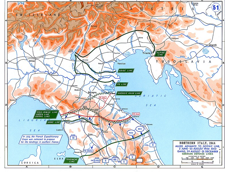
English: Allied Corp formations are depicted in blue. The German defensive lines are shown in green. The solid red line denotes the extent of the Allied advance by 29 August 1944, and the dotted red line is the extent of the Allied advance by 31 December 1944. |
| Data | |
| Font | Archive link to original website used for the map and the archive link to the map source page. |
| Autor | The History Department of the United States Military Academy |
| Permís (Com reutilitzar aquest fitxer) |
US Government document |
| Altres versions |
The current version of the map by the The History Department of the United States Military Academy: |

Llicència
Aquesta imatge és obra d'un soldat o empleat de l'exèrcit dels EUA feta durant la prestació oficial de servei. Com a obra del govern federal dels EUA, la imatge és en el domini públic.
|
 |
Historial del fitxer
Cliqueu una data/hora per veure el fitxer tal com era aleshores.
| Data/hora | Miniatura | Dimensions | Usuari/a | Comentari | |
|---|---|---|---|---|---|
| actual | 05:25, 20 feb 2021 | | 1.265 × 966 (1,89 Mo) | Buidhe | Reverted to version as of 14:07, 29 February 2020 (UTC) Not a minor change, should be uploaded as new file |
| 04:57, 20 feb 2021 |  | 973 × 754 (349 Ko) | EnigmaMcmxc | updated version of the map | |
| 16:07, 29 feb 2020 |  | 1.265 × 966 (1,89 Mo) | Hohum | Fix colour profile | |
| 20:21, 22 juny 2011 |  | 1.265 × 966 (1,93 Mo) | Hohum | Cleanup | |
| 14:26, 10 des 2006 |  | 1.265 × 966 (2,01 Mo) | MatthiasKabel | == License information == {{PD-Layout}} {{PD-USGov}} Original from http://www.dean.usma.edu/history/web03/atlases/ww2%20europe/ww2%20europe%20war%20index.htm |
Ús del fitxer
La pàgina següent utilitza aquest fitxer:
Ús global del fitxer
Utilització d'aquest fitxer en altres wikis:
- Utilització a af.wikipedia.org
- Utilització a ar.wikipedia.org
- Utilització a cs.wikipedia.org
- Utilització a de.wikipedia.org
- Utilització a en.wikipedia.org
- Utilització a es.wikipedia.org
- Utilització a fi.wikipedia.org
- Utilització a fr.wikipedia.org
- Utilització a he.wikipedia.org
- Utilització a hu.wikipedia.org
- Utilització a id.wikipedia.org
- Utilització a it.wikipedia.org
- Utilització a ja.wikipedia.org
- Utilització a nl.wikipedia.org
- Utilització a no.wikipedia.org
- Utilització a pl.wikipedia.org
- Utilització a pt.wikipedia.org
- Utilització a ru.wikipedia.org
- Utilització a sk.wikipedia.org
- Utilització a sl.wikipedia.org
- Utilització a sr.wikipedia.org
- Utilització a sv.wikipedia.org
- Utilització a ta.wikipedia.org
- Utilització a uk.wikipedia.org
- Utilització a www.wikidata.org
- Utilització a zh.wikipedia.org