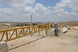
Surif
| صوريف | ||||
| Tipus | ciutat, gran ciutat i satellite city (en) | |||
|---|---|---|---|---|
| Localització | ||||
| ||||
| Municipi | ||||
| Graella palestina | 156/117 | |||
| Geografia | ||||
| Superfície | 15 | |||
| Organització política | ||||
| Governació | Hebron | |||
Surif (àrab: صوريف, Ṣūrīf) és un municipi palestí de la governació d'Hebron, a Cisjordània, situat 25 kilòmetres al nord-oest d'Hebron. Segons l'Oficina Central Palestina d'Estadístiques tenia 17.650 habitants el 2016.[1] La majoria dels 15.000 dúnams del municipi són usats per l'agricultura, en particular olives, blat i ordi.[2] Hi ha set mesquites i quatres escoles al municipi.
Història
[modifica]Mandat Britànic de Palestina
[modifica]En el cens de Palestina de 1922, dut a terme per les autoritats del Mandat Britànic, Surif tenia 1.265 habitants, tots musulmans[3] incrementats en el cens de Palestina de 1931 a 1.640 musulmans en 344 cases habitades.[4]
Després de 1948
[modifica]Després de la Guerra araboisraeliana de 1948 i els acords d'armistici de 1949, Surif va quedar sota un règim d'ocupació jordana. Des de la Guerra dels Sis Dies en 1967, Surif ha romàs sota ocupació israeliana.
Referències
[modifica]- ↑ 2007-2016 PCBS census Arxivat 2013-07-05 at Archive.is. Palestinian Central Bureau of Statistics (PCBS). p. 107.
- ↑ The Segregation Separation Wall hits the lands of Surif and Khibet Ad Deir- Hebron district Arxivat 2005-12-21 a Wayback Machine. Land Research Center 2004-10-24
- ↑ Barron, 1923, p. 10
- ↑ Mills, 1932, p. 33
Bibliografia
[modifica]- Barron, J.B.. Palestine: Report and General Abstracts of the Census of 1922. Government of Palestine, 1923.
- Conder, C.R.; Kitchener, H.H.. The Survey of Western Palestine: Memoirs of the Topography, Orography, Hydrography, and Archaeology. 3. Londres: Comitè del Fons per a l'Exploració de Palestina, 1883. (p. 309)
- Gobierno de Jordan, Departamento de Estadística. First Census of Population and Housing. Volume I: Final Tables; General Characteristics of the Population, 1964.
- Gobierno de Palestina, Departamento de Estadística. Village Statistics, April, 1945, 1945. (p. 23)
- Guérin, V. Description Géographique Historique et Archéologique de la Palestine (en francès). 1: Judee, pt. 3. París: L'Imprimerie Nationale, 1869. (pp. 381-382)
- Hadawi, S. Village Statistics of 1945: A Classification of Land and Area ownership in Palestine. Palestine Liberation Organization Research Center, 1970. (pp. 50, 94, 144)
- Hartmann, M. «Die Ortschaftenliste des Liwa Jerusalem in dem türkischen Staatskalender für Syrien auf das Jahr 1288 der Flucht (1871)». Zeitschrift des Deutschen Palästina-Vereins, 6, 1883, pàg. 102–149. (p. 143)
- Mills, E.. Census of Palestine 1931. Population of Villages, Towns and Administrative Areas. Jerusalem: Government of Palestine, 1932.
- Palmer, E.H.. The Survey of Western Palestine: Arabic and English Name Lists Collected During the Survey by Lieutenants Conder and Kitchener, R. E. Transliterated and Explained by E.H. Palmer. Comitè del Fons per a l'Exploració de Palestina, 1881. (p. 408)
- Robinson, E.; Smith, E. Biblical Researches in Palestine, Mount Sinai and Arabia Petraea: A Journal of Travels in the year 1838. 3. Boston: Crocker & Brewster, 1841. (p. 117)
- Schick, C. «Zur Einwohnerzahl des Bezirks Jerusalem». Zeitschrift des Deutschen Palästina-Vereins, 19, 1896, pàg. 120–127. (p. 122)
- Socin, A. «Alphabetisches Verzeichniss von Ortschaften des Paschalik Jerusalem». Zeitschrift des Deutschen Palästina-Vereins, 2, 1879, pàg. 135–163. (p. 161)
Enllaços externs
[modifica]- Welcome To Surif
- Survey of Western Palestine, Map 21: IAA, Wikimedia commons
- Surif Town (Fact Sheet), Applied Research Institute–Jerusalem, ARIJ


