An-Naqura
Aparença
| الناقوره | ||||
| Tipus | poble | |||
|---|---|---|---|---|
| Localització | ||||
| ||||
| Vila | ||||
| Graella palestina | 169/185 | |||
| Geografia | ||||
| Altitud | 445 m | |||
| Organització política | ||||
| Governació | Nablus | |||
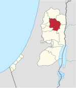
An-Naqura, o també al-Nakura (àrab: الناقوره, an-Nāqūra), és un vila palestina de la governació de Nablus, a Cisjordània, al nord de la vall del Jordà, 10 kilòmetres al nord-oest de Nablus. Segons l'Oficina Central Palestina d'Estadístiques tenia 1.545 habitants en 2007.[1] An-Naqura és administrada per un consell de vila de 10 membres encapçalat per Muhammad Hashish.[2]
Referències
[modifica]Bibliografia
[modifica]- Barron, J. B.. Palestine: Report and General Abstracts of the Census of 1922. Government of Palestine, 1923.
- Conder, Claude Reignier; Kitchener, H.H.. The Survey of Western Palestine: Memoirs of the Topography, Orography, Hydrography, and Archaeology. 2. Londres: Comitè del Fons per a l'Exploració de Palestina, 1882. (p. 160)
- Department of Statistics. Village Statistics, April, 1945. Government of Palestine, 1945.
- Ellenblum, Ronnie. Frankish Rural Settlement in the Latin Kingdom of Jerusalem. Cambridge University Press, 2003. ISBN 9780521521871. (p. 248)
- Hadawi, S. Village Statistics of 1945: A Classification of Land and Area ownership in Palestine. Palestine Liberation Organization Research Center, 1970.
- Mills, E.. Census of Palestine 1931. Population of Villages, Towns and Administrative Areas. Jerusalem: Government of Palestine, 1932.
- Palmer, E. H.. The Survey of Western Palestine: Arabic and English Name Lists Collected During the Survey by Lieutenants Conder and Kitchener, R. E. Transliterated and Explained by E.H. Palmer. Comitè del Fons per a l'Exploració de Palestina, 1881. (p. 188)
Enllaços externs
[modifica]- Welcome To al-Naqura
- Survey of Western Palestine, Map 11: IAA, Wikimedia commons
- An Naqura Village profile, Applied Research Institute - Jerusalem, ARIJ
- al-Naqura, aerial photo, ARIJ
- Development Priorities and Needs in An Naqura, ARIJ


